Showing posts with label mudslide. Show all posts
Weather related highway closures
Posted by Unknown in landslide, mudslide, rain, road closures on Monday, January 5, 2015
Updated: 5:05 p.m. Friday, Jan. 9, 2015
Several highways remain closed near the Washington coast after heavy rains brought debris down over the roadway beginning in the early morning hours of Monday, Jan. 5. We will continue to update this post when information changes.
These closures are in effect:
- US 101 at milepost 72.6 near Artic will remain a single lane with reduced speeds and one-way alternating traffic at Rock Crusher Hill until further notice. Stop signs provide traffic control. Motorists are asked to please adhere to the stop signs in place and follow the rules of one-way alternating traffic. Heavy rains early Monday morning triggered movement at a historic landslide site. WSDOT has completed the design for a permanent repair, and has requested construction funding for the repair in the 2015-2017 biennium.
- At US 101 near milepost 79 near Cosi Hill, the left northbound lane is closed; one lane in each direction is open and the lanes have been shifted to the southbound lanes and shoulder.
- US 101 at milepost 75 has single lane alternating traffic controlled by flaggers.
 |
| US 101 at milepost 72.6 will remain a single lane with reduced speeds and one-way alternating traffic controlled by a stop sign at Rock Crusher Hill until further notice. |
WSDOT will opened a temporary bypass around a damaged portion of State Route 4 at milepost 3.1, just west of Naselle, Friday, Jan. 9.The road will be open to two-way traffic with a reduced speed of 15 mph. The highway was damaged when a culvert failed during heavy rain, Monday, Jan. 5.

Permanent repairs to the highway and the culvert will take several months. Crews are hauling material in to construct a connection from SR 4 to a bypass road, which is an old highway that runs parallel to the damaged road. Paving work will need to be completed before it is open to two-way traffic with a reduced speed limit of 15 mph. The work is weather dependent.
 |
| SR 4 wash out between US 101 and SR 401. More photos available on Flickr. |
CLEARED - Both lanes of I-90 Snoqualmie Pass have reopened. Snoqualmie Pass received more than 8 inches of rain in the past 24 hours saturating the soil causing rock fall along the slopes east of I-90.
CLEARED - US 12 at milepost 1 is open to traffic in all directions outside of Aberdeen.
CLEARED - SR 109 in both directions.
Cleared: All lanes of US 101 (milepost 29 to 53.5) in South Bend are open.
CLEARED - US 101 at milepost 64 is now open after more than a foot of water prevented travel on the roadway early Monday.
CLEARED - SR 105 all lanes are now open. Earlier a slide had blocked both directions from Smith Creek Bridge (milepost 10) and Airport Road (milepost 4.5).
CLEARED - SR 203 is closed in both directions from Tolt Hill Road in Carnation to SR 202 in Fall City due to water over the roadway.
CLEARED - SR 202 is closed from SR 203 to Southeast Fish Hatchery Road northeast of Fall City due to water over the roadway.
CLEARED - SR 11/Chuckanut Dr. is closed between Avon Allen Rd and Field Rd due to water over the roadway.
CLEARED - SR 538 is closed in both directions in Mount Vernon between Horton Road (milepost 5) and SR 9 (milepost 3).
What we’re doing to prevent landslides near rail lines
Posted by Unknown in Amtrak Cascades, gravity, landslide, mudslide, passenger train, rail, rain on Friday, January 2, 2015
By Barbara LaBoe
You can’t fight Mother Nature. But when it comes to landslides that block rail lines north of Seattle, we’re trying to call a truce.
 |
| This 1997 Department of Ecology picture of a landslide near Woodway, WA shows how devastating slides can be to property and rail lines. |
BNSF Railway Company owns and operates the railway. For each landslide on the north rail line, BNSF sets a minimum 48-hour moratorium on passenger rail service between Seattle and Everett. During that time, BNSF clears debris, repairs the tracks and checks the slope. While moratoriums are in effect, buses transport our Amtrak Cascades passengers between the Seattle and Everett stations to continue their train journeys.
We manage the Amtrak Cascades passenger rail service along with the Oregon Department of Transportation. Amtrak operates the service for the two states. So we take train safety and landslide disruptions seriously.
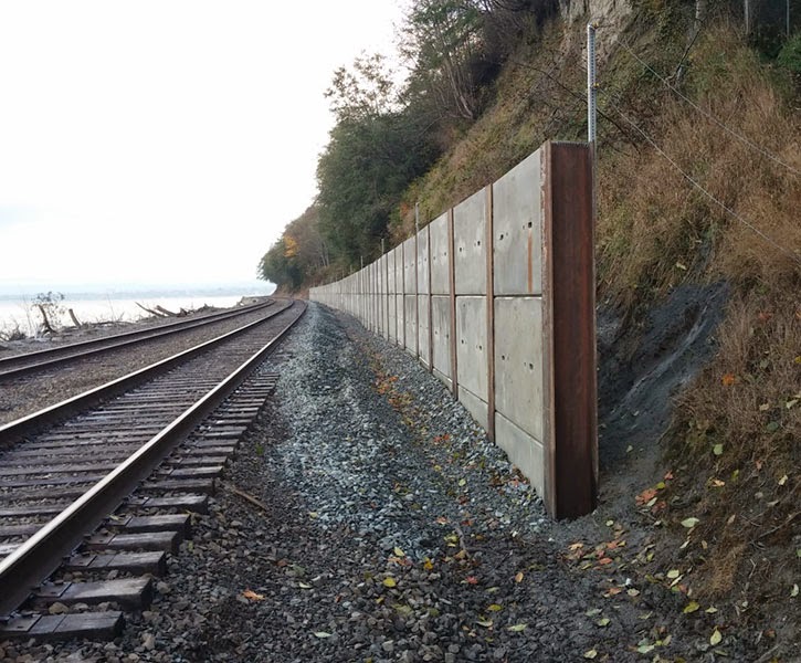 |
| Retaining walls, like this one, help catch and contain landslide debris before it can reach the tracks. |
We also, along with other work group members, held three educational open houses in communities along the north rail line to allow landowners to learn about landslide risks and prevention on their property. We met with mayors and city councils this year in Mukilteo, Edmonds and Everett about the issue. And a brochure with information and prevention tips (pdf 340 kb) was mailed to landowners along the affected rail corridor. In some cases, preventive measures are simple, such as planting native vegetation to prevent erosion and reduce the risk of landslides. New or reworked drainage systems also can help stabilize the slope and safeguard property -- as well as the rail lines. As part of this process, BNSF also agreed to waive permit fees through April 2015 for landowners who connect to the railroad’s drainage system.
- Retaining walls to catch landslide debris before it hits the tracks.
- Slide detection fences to give early warnings of active landslides.
- Improved drainage systems.
- Erosion control.
 |
| Stabilizing land and reducing the steepness of a slope, as shown here near Mukilteo, can also help prevent landslides. |
Of course, there’s never a 100 percent guarantee when you’re dealing with landslides. But by addressing landslide risks and prevention head-on, we hope to reduce at least some of Mother Nature’s impact.
SR 530 closed indefinitely after Snohomish County landslide
Posted by Unknown in 530slide, Darrington, landslide, mudslide, Oso, Snohomish County, SR 530, Stillaguamish River on Monday, March 24, 2014
After the tragic landslide along SR 530 in the town of Oso on Saturday morning, search and rescue operations are underway for many unaccounted people in Snohomish County. SR 530 between Whitman Road (milepost 36) and 310th Street Northeast (milepost 39) is closed indefinitely. It’s likely a long-term closure.
A hillside gave way about five miles east of Oso, and north of SR 530 across the north fork of the Stillaguamish River. The affected area is about a mile wide and estimated to be up to 35 feet deep in places. The headscarp, the location on the hill where the slide began, is about 1,500 feet wide and 600 feet tall.

We are working closely with Snohomish County, Washington State Patrol and a number of other state and local partners in the emergency response.
Right now, it’s not safe for crews to go into the slide area. Silt is still moving from hillside, which is potentially hazardous to crews below. We’re helping clear some mud from the road to blaze a trail for rescue workers, but it’s too soon to tell how much damage has been done to the highway.
At the moment, geologists from several agencies including WSDOT are on-scene and monitoring the hillside for the safety personnel watching for further safety issues.
There are no good detour options around the portion of SR 530 affected by the mudslide. Those heading to and from Darrington need to use SR 530 to SR 20, and then take I-5. The detour is about an hour.
We also teaming up with Snohomish County to clear snow from Mountain Loop Highway. It’s a seasonal auxiliary road owned by the county and Forest Service that usually is closed in the winter. Once opened, the 25 mph gravel road will serve as an emergency route to and from Darrington. Crews working on the clearing effort reached the summit of Mountain Loop Highway around 11:30 a.m. today. Previous reopening estimates indicated the highway would open Thursday. There is potential that the work will be completed earlier than planned.
Currently, we are reaching out to potential contractors so we can start cleanup efforts as soon as possible. Governor Inslee declared a state of emergency late Saturday night so that we can apply for federal relief funds to cover the cleanup costs for reopening SR 530.The current slide is unrelated to previous work on the south side of the highway at Skaglund Hill. Between 2006 and 2012, our contractor crews installed a rock buttress along the south bank of the Stillaguamish River just below SR 530. This reinforced and stabilized the hillside. We also installed a series of drainage pipes into the hillside and a rock wall that cost $13.3 million.
Frustrated with mudslides along the Amtrak Cascades rail line
Posted by Unknown in Amtrak Cascades, mudslide on Wednesday, February 16, 2011

The last three months have been very frustrating, for you and us. We’re working hard to support, improve, and promote Amtrak Cascades as a viable transportation option. When the trains aren’t running, it impacts us all.
It is expected that we will have some mudslides along the Amtrak Cascades rail line between October and March, but this is ridiculous! Normally, we average anywhere from three to 10 mudslides over a six-month period, but in the last three months we’ve had nearly 20.
There were 16 mudslides that kept 90 trains from reaching their destination in Dec. 2010 alone. Seventy-eight of those trains were on the Seattle to Vancouver, B.C., leg. This happens to be our most mudslide-prone problem area.
What’s even worse is that any time there is a mudslide, regardless of how severe, an automatic 48-hour moratorium is imposed on passenger rail service. All passenger rail service comes to a halt, and as you can imagine, this is very inconvenient for passengers, Amtrak and us. Adding to the frustration is the fact that the moratorium doesn’t apply to freight rail service.
Obviously, this is done for safety reasons. Freight trains carry goods and passenger trains carry people. As you’d expect, people rate higher than a train carrying athletic shoes and televisions. Plus, it is important to ensure that the area where a mudslide occurred is stable before sending passenger trains through.

What are we doing about the mudslides, you ask? There are more than 60 areas along the 466-mile route for Amtrak Cascades that have been identified as at risk for mudslides. That’s a lot of area to cover. The majority of mudslides occur in the Everett area. There are also a decent number of mudslides in British Columbia that affect our trains.
This not only affects Amtrak Cascades, but also Sound Transit’s Sounder and the Amtrak Coast Starlight long-distance train and BNSF Railway freight trains. We are working with Sound Transit, Amtrak and BNSF to find a solution. The biggest challenge is funding. Before we can start any improvements, we have to complete an environmental assessment (EA) to determine potential key environmental impacts before beginning any construction. There is currently no funding for the EA – without it, we can’t begin construction to fix the problem.

In the meantime, we hope that the rain and mudslides subside so the trains can continue running unimpeded. Amtrak Cascades finished 2010 with extraordinary ridership totals (838,251 an all-time high) and we added free Wi-Fi at the end of January. Kudos to our partner Amtrak for doing their best to get people where they need to go in spite of the mudslide challenges.
Rain causing havoc throughout state...
Posted by Unknown in flood watch, flooding, mudslide, rain, snoqualmie pass, t, wsdot on Wednesday, January 7, 2009
Summit East Slide
Originally uploaded by Washington State Dept of Transportation.

An amazing amount of rain is falling on Washington today. At one point we have counted over 60 road closures due to water over the roadway. Pictures are rolling in of the incredible damage that has been caused due to melting snow and rainfall.
This photo is of the Summit East ski area of Snoqualmie pass. Check our Flickr account throughout today and tomorrow for more pics of the terrible damage all this water is causing.
http://www.flickr.com/photos/wsdot/

 |
 |
 |
 |
 |
 |
 |
 |
 |
 |
 |
 |
 |
 |
 |


