Showing posts with label search and rescue. Show all posts
Pre-flight check: Can we find you?
Posted by Unknown in 406 ELT, aviation, emergency locater transmitter, flight plan, search and rescue on Thursday, August 9, 2012
Working out of the Wenatchee airport, searchers flew grid patterns (based on the route he most likely took), scoured mountainous terrain and chased leads. Sadly - after six and a half days of searching, dried-up leads and exhausted resources – we had to suspend the search.
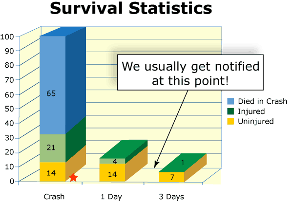
When a plane goes missing, it’s a race against the clock to try to get as much information as possible. When hours turn into days, the chances of a favorable outcome decrease drastically.
So now we have a sobering reminder to pilots and anyone who cares about someone who flies. No one wants to think they might one day be the subject of a search. However, the old adage –“expect the best and prepare for the worst” might just be the key to saving a pilot’s (and any passengers’) life.
Our goal is no plane ever goes missing. But if the worst happens, here are some things that will make it easier for emergency crews to find the plane faster:
File a flight plan – a flight plan will tell searchers where you were heading and your intended route. This information can be critical during a search.
Use flight following – talking to air traffic control (ATC) during your flight can pay dividends if you go missing. ATC would have radar information and details about when they last spoke to you, where you were heading, and if you had reported any in-flight troubles.
Make sure you have an operational emergency locator transmitter – the key word here is “operational.” Check it out every so often to make sure it’s working. ELTs transmit distress signals in emergencies and help search crews find your location. ELTs are required in most U.S. registered civil aircraft.
Consider investing in a new 406 ELT – several years ago, a more advanced model of the ELT (406 mhz) was developed. This version will cost around $550 per unit, but has an 80 percent chance of activating upon impact. And it will tell searchers your tail number and exact location. This could mean the difference between hours and minutes when it comes to searches.
Air search and rescue
Posted by Unknown in EOC, lost aircraft, lost pilot, SARSAT, search and rescue on Monday, February 13, 2012

Over the weekend, a plane went down near Mount Baker – near the 7,800 foot level. Our Aviation Search and Rescue Division got the call and headed up to Bellingham to coordinate the search. What – you may ask – does the state highway department have to do with search and rescue?
Great question. Our responsibility, as directed by the Legislature, is to manage all Air Search and Rescue operations within the state as well as coordinating the use of aviation assets for disaster relief efforts. So that means when the emergency beacon went off Saturday night, we got the call.
Satellites monitor for emergency beacons – through a system called SARSAT. The SARSAT office then notifies the state Emergency Operations Center (Washington Emergency Operations Center is located at Camp Murray). The EOC Duty Officer got the call, which then came to us.
Once we had the location, and contact information for the beacon’s owner (good thing he registered – hint, hint), we called the family to confirm. Yes, the Bellingham man had taken the plane out over Mount Baker to take photos, and yes, he hadn’t returned as scheduled.
Our Aviation Search and Rescue team (led by Tom Peterson), then started up to Bellingham. We have a trailer that serves as a mission control center. He also called the U.S. Navy and it was fortunate a team from Naval Air Station Whidbey was available to start searching. Weather was cooperating also so the team could fly during the night.
The pilot’s wife then called the local sheriff’s office – apparently she received a short phone call and he was okay. Cellular reception is spotty in that rural area, so she didn’t have much more info.
With that confirmation the plane was actually out there, a team from the Skagit County Sheriff’s Office took snowmobiles out, starting from what is known as Shrieber’s Meadow. They found the plane - damaged and upside down on the edge of the Deming Glacier at the 7,800-foot level of Mount Baker. (A bit of trivia – those beacons actually work – the plane was less than 150 feet from where it was supposed to be.)
No pilot or passenger inside. As luck would have it, a group of snowmobilers were also out, and they got stuck and were able to radio some friends. On the way out, their friends found the pilot and his passenger, so they brought them back.
The pilot called from his home, reporting he was okay.
Our role was to find the plane, coordinating all available resources. We also do this during natural disasters – coordinate all aviation resources to help rescue those stuck during floods, etc. This time, it was fortunate the U.S. Navy and local sheriff’s office were there to help. That isn’t always the case.
Once we found the plane, we turn the rescue operation over to the local law enforcement and the FAA and NTSB come in to investigate the crash. Mission complete.

 |
 |
 |
 |
 |
 |
 |
 |
 |
 |
 |
 |
 |
 |
 |


