I-5 gets smarter on Aug. 10
Posted by Unknown in congestion relief, Smarter Highways on Friday, July 30, 2010
On your mark, get set, get smart. Not Maxwell Smart. We’re talking Smarter Highways.
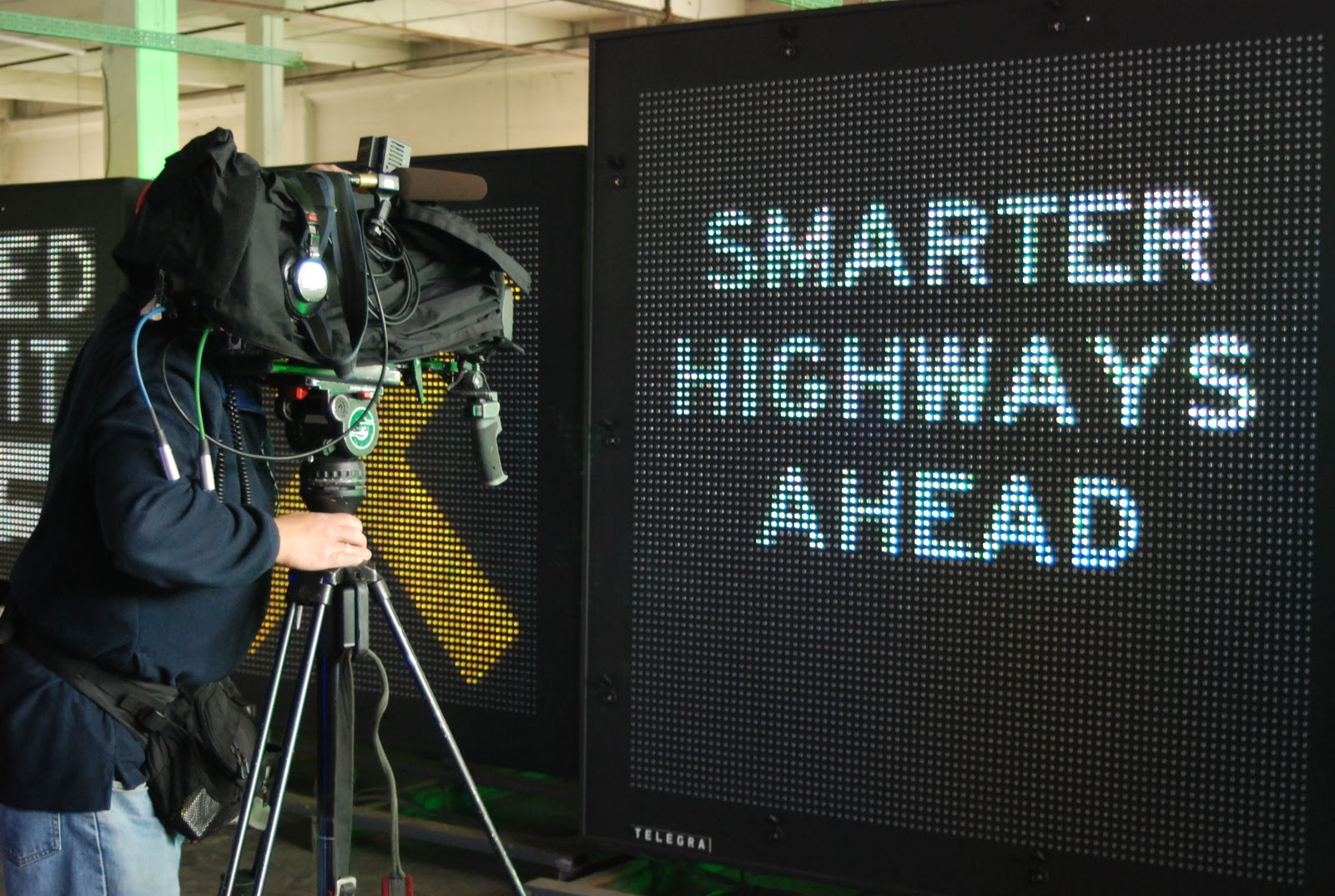
If you’ve driven northbound I-5 between Boeing Access Road and I-90 recently, you’ve probably noticed a whole bunch of new electronic signs over the freeway. These are our Smarter Highways signs. Since we began testing them in May, the new signs have displayed bunches of random dots, asterisks and other cryptic test messages.
Starting Aug. 10, the test messages will go away and the new signs will officially get smart. That means it’s time for you to get smart, too.
When the signs go live, they’ll be giving drivers real-time traffic information about what’s happening on the road ahead through a series of Xs, arrows and electronic messages. If you’re wondering what that’ll look like, you can check out a video of how the signs will work on the Smarter Highways website.
So what makes these signs smarter than the electronic signs we already have on I-5? For one thing, they’re stationed every half-mile along I-5. That means we can get more specific traffic information to drivers well before they get stuck in congestion. And because we have a sign positioned above each lane on the freeway, we can let drivers know exactly which lanes are blocked and which lanes are open. We can even let drivers know to adjust their speed before they reach slower-moving traffic.
This information means that drivers can change lanes ahead of time or even get off the freeway to avoid congestion. It’ll also help reduce the number of rear-end crashes that can happen when drivers suddenly find themselves in slowing traffic.
As regular commuters probably know, crashes cause congestion, congestion in turn causes more crashes, and those crashes in turn cause more congestion. It’s a vicious cycle, especially during rush hour. Since building nine miles of new lanes on I-5 isn’t a feasible or affordable option, we had to find a way to make our highways work more efficiently. There’s an old saying: Don’t work harder, work smarter. And that’s exactly what these signs will do for our highways.
We’re getting smart. How about you?
Bridge safety, federal report released
While I take responsibility for the safety of myself and my family, the last thing I want to have to think about when I hit the highway is how safe the roads or bridges might be.
The U.S. Government Accountability office recently released a report about bridge safety recently that, in short, stated: “Congress received a report today that says ‘one in four bridges in the United States is either structurally deficient and in need of repair, or functionally obsolete and is not adequate for today’s traffic.’”
What does that mean for those of us who drive in Washington state? Of the more than 3,600 bridges owned and maintained by the state, 97 percent are in good or fair condition. That number ranks us 27 in the nation among states with the highest number of structurally deficient bridges. Yes, I paused at the word "structurally deficient," too. Fortunately, it sounds more dramatic than it actually is. After doing some research, I found out that it is just a fancy engineering term for "still safe, but on the list to have some work done."
In light of this report, we wanted to make sure you knew that we are working hard to preserve and maintain our roads and bridges (see the June 2009 bridge assessment pdf). Since 2000, we have invested nearly $850 million towards bridges (nearly half of that was spent on the Hood Canal Bridge project). The 2005 transportation funding package also provided $87 million to strengthen bridges in case of an earthquake. More good news is that we are making progress on our most vulnerable structures, the Alaskan Way Viaduct and the SR 520 floating bridge. Want to learn more about what we are doing? Be sure to check out the Gray Notebook where we have been reporting since 2001 about what we are doing to make sure our bridges remain safe.
DOT Announces Second Distraction Summit
Posted by Unknown on Wednesday, July 28, 2010
The DOT officially announced they will be hosting the second summit on distracted driving on September 21st in Washington, DC. As a participant in last year’s summit, we experienced firsthand the instant attention the distraction issue garnered both during and after the event. Great strides have been made bringing this issue to the front of the agenda with many states enacting texting or handheld bans over the past year. These legislative pushes have kept the issue of distraction in the public eye for much of the year and I hope this year’s summit will continue to shedding more light on this important traffic safety issue. However, I’ve always said passing legislation is not enough; we must go beyond that by trying to convince the driving public to change their behavior when it comes to distraction. I truly hope this year’s summit will help push the traffic safety community toward achieving this ultimate goal.
Okay, who sprayed Miracle-Gro on the signs?
“I think these signs have been sprayed with Miracle-Gro. They are popping up everywhere!” – WSDOT Maintenance Superintendent.
I heard that today about campaign signs.
So it’s time for a friendly reminder that campaign signs are not allowed in the state highway right-of-way. If we see signs (campaign or other) in the right-of-way, we take them down. But we just can't get to every one.
To stop the election season “growing," we work with local Auditors to educate candidates and volunteers. It’s not always easy to know the boundaries, so here are a few clues:
- Utility poles are typically located inside the right-of-way. So no signs between the pole and the road.
- Many locations also have a fence line separating the right-of-way from private property. So again, no signs between the fence and the road.
The above information is for state highways. Local municipalities have their own regulations, which may differ from city to city and county to county.
The best way to determine the boundary lines for a state highway right-of-way is to check with WSDOT Outdoor Advertising Specialist Pat O’Leary. He can be reached at OLearyP@wsdot.wa.gov or by calling (360) 705-7296. You will need to provide the state route number (I-5, SR 28, US 2, US 97, etc.) and the name of the nearest intersection or approximate milepost.
For those who are curious about the highway signs on private property, check out Washington Administrative Code 468-66 . With an okay from the property owner, temporary political signs are allowed on private property visible from state highways.
If you find your sign was taken down and you would like it back, contact your local WSDOT Maintenance Office. No guarantees, but it could still be around.
Road Features Do Save Lives...
Posted by Unknown on Tuesday, July 20, 2010
There’s no doubt that nearly all crashes on our roadways are preventable. Talking on cell phones, using an ipod or GPS, driving aggressively or simply not adjusting to weather conditions are all causes of crashes, but are also things that are under the drivers’ control. Given this, I continue to encourage all drivers to examine their own driving behaviors and eliminate the habits that put yourself and others at risk. However, I also understand that all drivers are human and mistakes can be made. This is why building roads with safety features like guardrails, rumble strips and additional pavement markings are important to roadway safety. When driver error occurs and mistakes are made on the road, these features can save lives. One of the greatest reasons road safety features are needed is to prevent Run-Off-the-Road crashes, an issue the AAA Foundation and collaborating organizations helped address earlier this year through a campaign which resulted in a national PSA and educational DVD. Building roads with key safety features is an important step for highway safety, but we must remember the fastest, easiest and most effective way to improve safety is for everyone to start being smart-focused drivers on the road.
Summer Safety For Teens
Posted by Unknown on Wednesday, July 14, 2010
It’s no secret that teen drivers have one of the highest crash rates of any age group. Their lack of knowledge and experience in handling specific driving scenarios not surprisingly makes them more likely to be in a crash. Unfortunately, statistics have shown that these risks are even greater during the summer between Memorial Day and Labor Day – the deadliest for drivers age 15-20. This shouldn’t come as a huge surprise because summer means free time, less supervision and more opportunities for teens to drive. However, it’s important that every driver makes an effort to avoid the distractions that summer offers. Warmer weather is a factor as more drivers put their windows or rooftops down - making it easier to be distracted by what’s going on alongside the road instead of looking straight ahead. More travelers going on vacation or to the beach means more passengers and the potential for increased distraction for drivers. Our 2009 Index survey found that 35% of drivers felt less safe now than they did five years ago – the number one reason cited was distracted driving. We’re now halfway through summer and I want encourage ALL drivers to keep their focus where it belongs – on the road.
What? You are tearing down the southern mile of the viaduct this summer?
Posted by Unknown on Friday, July 9, 2010
Got your attention, didn't I! The southern mile of the Alaskan Way Viaduct is coming down, but not before celebrating with a groundbreaking and building part of the new side-by-side roadway that will replace it.
Sections of the new roadway will be open in early 2012, and soon after that we'll cue the wrecking balls to bring down the the old structure. Remember - we're starting with the southern mile only. The middle section - the part with the view - will remain open through 2016.
In case you missed it, we held the groundbreaking ceremony on Tuesday, June 29.
Transportation Secretary Paula Hammond, flanked by local and state-wide politicians and council members, spoke to a crowd of more than 100 people.

After the dignitaries said their remarks, they plunged shovels into a pile of fresh dirt and officially "broke ground" on the southern mile viaduct replacement project.
Yeah, yeah; but where the heck is the southern mile of the viaduct?
Good question. Basically, it is the portion of the double-decker viaduct that starts at the First Avenue S. ramps near S. King Street and Safeco Field, and ends at S. Holgate Street where SR 99 becomes a surface street. View a project map.

We painted two of the columns bright orange at the northern end of the S. Holgate Street to S. King Street Viaduct Replacement Project.
 When we're all done the new, side-by-side roadway will look like the image to the left. The "U-shaped" part will be a new crossing on S. Atlantic Street, so trucks can still get to the port when trains are on the nearby tracks. Construction starts in late July and will last through 2013. We are committed to keeping people and goods moving during construction. In fact, our highway engineers designed a way to keep at least two lanes of SR 99 open in each direction while we're building the new roadway.
It's a complicated design, but the gist of it is that we plan to build one half of the new SR 99 roadway west of the existing viaduct between S. Royal Brougham Way (near Safeco Field) and S. Holgate Street (where the elevated viaduct becomes a surface street.)
Once this section of roadway is built, we'll shift both directions of traffic onto it, and begin to tear down the existing viaduct. Then crews will get to work building the second half of the new roadway from S. Royal Brougham Way to S. King Street.

Check out this neat interactive simulation to see how we're going to sequence construction and keep traffic flowing at the same time.
Have a question? Want to know more? Great! Go ahead and contact me at Benderb@wsdot.wa.gov or visit the Alaskan Way Viaduct Replacement Project website: www.wsdot.wa.gov/Projects/SR99/HolgateToKing/.
Roads and fire danger
Posted by Unknown in fire, roadsides, vegetation management
The WSDOT Office of Emergency Management just sent out its first fire warning.
This email stated “Today, the National Weather Service has updated the Fire Weather Watch to a Warning (Red Flag Warning) today until 10 p.m. tonight for Klickitat County due to low humidity and gusty winds in the Columbia Gorge area.” According to the Weather Service, a Red Flag Warning means critical fire weather conditions are either occurring now or will shortly. A combination of strong winds and low relative humidity will create explosive fire growth potential.
We do our best to manage the grasses and other roadside vegetation as weather heats up. We also include safety features, such as water access, in roadway design, so emergency response agencies have access to fire-fighting materials.
But, weather conditions can change quickly. The human element also comes in when a motorist tosses lit debris, specifically lit cigarettes. Tossing litter, including cigarette butts, can result in a $1,025 fine. (See more from the Office of the State Fire Marshal)
If you see a fire, please report it to Emergency Services. You can also report litter violators to the Department of Ecology's litter hotline at 1-866-LITTER1 or file a report online.
Here are some other ways you can find out about fire danger in your area:
- Washington State Department of Natural Resources (DNR) fire Twitter feed.
- DNR's Fire hotline is 1-800-562-6010
- DNR fire danger by county map
WSDOT will be open for business on July 12 – a furlough day for others
Posted by Unknown in furlogh, temporary layoffs on Thursday, July 8, 2010
by guest blogger Ann Briggs
We’ve all been hearing a lot about temporary layoffs (also called furloughs) for state government agencies and you might be wondering how the closure of state offices will affect you.
It’s all a bit confusing, since not all agencies will have temporary layoffs on all of the 10 days that were selected by the legislature – the first one falls on Monday, July 12. The new temporary layoff law (ESSB 6503 for those of you want to dig into the nitty gritty of the bill language) allowed state agencies to come up with an alternate plan to achieve the compensation savings in other ways. Adding to the confusion, some agencies were exempted and portions of some agencies’ operations were exempted.
So where does that leave us? We opted to propose an alternate plan that was then approved by the Office of Financial Management (OFM). We also have staff who will be exempted from temporary layoffs in order to deliver critical public services. For us this includes “the operation, maintenance and construction of state ferries and state highways.” Under this plan, we will achieve our $1.4 million compensation savings target by taking two layoff days. They are October 11, 2010 and March 11, 2011.
We chose these days (two of the 10 selected days listed in the law) because they fall during a slower period of activity. In October, our heavy construction season will be coming to an end and winter maintenance activities are just beginning to gear up. In March, we’ll be over the worst of our winter weather and most highway construction will not have yet started.
To make the temporary layoffs equitable for our staff and meet our reduction target, we took a narrow approach to how we applied exemptions. We are exempting only those employees who are engaged in “on the road” maintenance activities; “on the water” and “on the terminal” delivery of ferry service; and “on the grade” construction activities. That means more of our employee population will be subject to temporary layoffs and we can reach our $1.4 million target with fewer closure days.
For you, that means although many of our buildings and offices will be closed on October 11, 2010 and March 11, 2011, the ferries will continue running, we’ll keep construction projects on track, and our maintenance workers will be ready to respond to weather and roadway incidents.
As for this Monday, July 12 – it’s business as usual.
Independence Day travel recap - where did you go?
Posted by Unknown in holiday travel, indenpendence day, Traveler Information on Wednesday, July 7, 2010
I hope you had a safe Independence Day weekend. Nice weather, good people, well-behaved children, minimal wait times. I hope you were lucky enough to have a few of those. Olympia was pretty cold, but we were lucky enough to stay dry.
If you were on Washington’s roadways, you should be able to say yes to one – those minimal wait times. The Washington State Ferries were very busy per usual, but for the most part, those of you travelling over the hills and through the woods didn’t face too much traffic.
Over I-90 Snoqualmie Pass, the number were very similar to Independence Day 2008 (also a three-day weekend - when Independence Day fell on a Friday), however there was a spike in Monday evening traffic.
- Close to 200,000 vehicles traveled both directions of Snoqualmie Pass between Thursday and Monday, nearly the same amount of vehicles as in 2008.
- Close to 50,000 traveled Monday, almost 10,000 more than in 2008. The heaviest traffic was from noon to 9 p.m.
- We noticed more drivers travelling later in the day, with a pretty large spike in the 8 p.m. hour. That’s a good thing, since spreading the traffic out over the day helps reduce backups during peak times, and more traveling later helped keep the delays to a minimum.

As for the other days on I-90 (also in comparison to 2008):
- 2,700 fewer vehicles traveled Friday.
- 3,800 fewer vehicles traveled Saturday.
- 4,500 fewer vehicles traveled Sunday.
On I-5 from Shoreline (north Seattle) to the U.S./Canadian border
- For Friday through Monday there were 167,000 vehicles. This was a decrease of 8,200 (5 percent) compared to the same period in 2009.
- 3,400 fewer vehicles traveled Thursday.
- 1,300 fewer traveled Friday.
- 2,000 fewer traveled Saturday.
- Sunday travel was unchanged from 2009.
- 1,600 fewer traveled Monday.
I-5, Olympia to Chehalis (Thurston/Lewis county line)
Unfortunately, we had technical problems here, losing a traffic loop. So at this location we were unable to do a comparison.
US 2, Stevens Pass
For Friday through Monday we counted a total of 39,700 vehicles on US 2. This was an increase of 4,000 vehicles (10 percent) compared with the same period in 2009.
- 1,000 more vehicles traveled on Thursday.
- 800 more vehicles traveled Friday.
- 1,100 more vehicles traveled Saturday.
- 500 more vehicles traveled Sunday.
- 600 more vehicles traveled Monday.
Interesting stuff…2010 actually shows lower volumes from 2009. And 2010 was a three-day state holiday. I wonder if it was the weather forecast. Or maybe everyone went somewhere else. The beach?
Name that highway
Posted by Unknown in naming, state highways, wsdot on Tuesday, July 6, 2010
Have you ever wondered how we name all our highways? It’s fantastically complicated, yet brilliantly explained by Mark Bozanich from one of our Olympia offices.
You’re probably familiar with the three different route-numbering systems that we use: Interstate, US and State Route. Examples of each include: Interstate 5; US 2; and SR 20.
The Interstate and US numbering systems are set up in a grid to cover the 48 contiguous states, plus the District of Columbia. Interstate highway numbers progress from west to east and south to north. US highway numbers progress from north to south and east to west. This minimizes the use of the same route number for an Interstate and a US highway within the same state.
Examples:
• US 10 is in the north and I-10 is in the south,
• US 5 is on the east coast and I-5 in the west.
One- and two-digit route numbers are used for the longer through-routes, and three-digit numbers are used for branches. Though, US 101 is an anomaly; it’s just the next odd-numbered through-route after 99.
The three-digit branch numbers use the second and third digits to identify the trunk or parent route. Thus, I-405 is a branch of I-5 and US 195 is a branch of US 95.
On the interstate system, branches that begin with even numbers make partial or full circles of an urban area. Branches that begin with odd numbers are spurs that link the parent route with a feature such as a downtown area not directly adjacent to the parent route (e.g., I-705 links I-5 with downtown Tacoma).
Now that we’ve covered the US and Interstate numbering systems, let’s move onto the State Route system.
The State Route system is in a grid that progresses from west to east and south to north. It does not use numbers used by Interstate or US routes within Washington State. Since we have US 2 and I-5, there are no other state routes with these numbers. US 101 is implicitly State Route 1.
The longer state routes tend to have one- or two-digit route numbers, and the shorter routes have three-digit numbers, like the Interstate and US routes.
Unlike the Interstate and US routes, however, the first digit or two digits indicate the trunk or parent route. Thus, SR 500, 501, etc., are considered to be branches of Interstate (implicitly State Route) 5, and SR 160, 161, etc., are branches of SR 16. There are some anomalies; SR 10, SR 99 and SR 410 are portions of former US 10, US 99, and US 410, and SR 92 and SR 96 are branches of SR 9.
There, now you’re a scholar of highway naming systems. Don’t say I didn’t warn you that it was a little complicated.
Here's an online highway map, in case you care to look up any of the highways mentioned.
Update on the Missouri DOT worker biking across the country...
Posted by Unknown in bike, fallen workers, memorial, MODOT on Friday, July 2, 2010
Wanted to give you an update on the Missouri DOT employee Kris Sandgren's progress as he rides across the nation to raise funds for a fallen worker memorial.
He is now on day 10 of his 2,600-mile bicycle ride, which started in Anacortes, and is now in northwestern Montana. Read more about his progress on the MODOT blog.
More State Texting-Bans Go Into Effect this Month
Posted by Unknown
There is no doubt that distracted driving is a serious issue with the U.S. Department of Transportation reporting that nearly 6,000 deaths and 500,000 injuries were the result of distraction related accidents in 2008. Six states will put texting-while-driving bans into effect this month with the aim of curbing this dangerous distraction while many states already have some type of ban in place. Legislation is a step in the right direction but it’s unclear just how effective it’s been so far in deterring behavior, especially given the penalty for being caught texting is as low as $20 in some states. However, the incentive to stop texting-while-driving shouldn’t be to avoid a fine or even obey the law. The true incentive is protecting the lives everyone on the road – passengers, pedestrians, other drivers and of course yourself. Our 2009 TSC Index found that 35% of people felt less safe on the road than they did five years ago. The main reason cited was distracted driving. We can all help make our roads safer by taking responsibility for our behavior behind the wheel and putting down the phone because it’s the smart thing to do.
Annual effort to reopen Artist Point about to begin
Posted by Unknown on Thursday, July 1, 2010
It's July and we still have snow burying one of our highways. July! I guess it's not all that unusual for snow to still be covering Mount Baker Highway at Artist Point this time of year. Especially since the stretch of highway we're talking about is nearly a mile above sea level. It's just weird, to me anyway, that it's July 1 and I'm writing about snow.
(Where and what is Artist Point?)
We took a scouting trip up to Artist Point last week in a snow cat to assess the snow conditions. A little reconnaissance mission, if you will, to find out what we'll be against this year when we start the annual effort to reopen the road. You'll never guess what we found on our trip: Snow! And lots of it, too.
The snow was anywhere from 15 to 20 feet deep in the upper parking lot. Crews couldn't even see the top of the restroom. It was completely buried. Most years, crews can see the top of the restroom peaking through the snow. Not this year. We never got the sun/warmth we needed in June to help melt back the snow at Artist Point.
We will start clearing the road on July 6. It's probably going to take a little longer to clear the road this year because of the deeper-than-usual snow. Usually, it takes anywhwere from two to three weeks, but this year could take a little longer. We'd like to get the road open in July... we'll see how it goes. Who knows, maybe the sun will show up in July and aid our crews in the snow-removal process. The sun can melt and move a whole lot more snow a lot faster than we can, that's for sure.
If you'd like to stay up to date on the clearing progress, you can subscribe for our Whatcom County e-mail updates and/or check the Artist Point website. We'll also post pictures on our Flickr account when we get new ones.
|
|
|
|
|
|
|
|
|
|
|
|
|
|
|
|
|
|


