Rentonite wins bet with boyfriend – is the first to use new on-ramp
Posted by Unknown in construction, I-405 on Thursday, December 30, 2010
By guest blogger Steve Peer
For months, Renton resident Tami Green watched construction on I-405 in her Renton neighborhood. When she learned that WSDOT was building a new on-ramp to northbound I-405 from Talbot Road, she realized her daily commute from Renton to Bellevue would be vastly improved because she wouldn’t have to go through downtown Renton to get on the freeway further north. She figured it would reduce her commute by 5-10 minutes each way. As the ramp began to materialize, she made an unusual wager with her boyfriend. She bet she would be the first to drive on the ramp.
So Green called someone with the City of Renton who immediately contacted us. We loved her idea of having a citizen open up a road so Tami became our honored guest. After all, we make improvements for real people, like Green, so it was a perfect fit.
On December 21 crews opened the new I-405 interchange and lanes to traffic in Renton as part of the Renton Stage 2 project. Tami Green was on hand to be the first to use the northbound on-ramp. She waved to construction workers, officials from the City of Renton and WSDOT as she was escorted by Renton Police vehicles onto I-405. The motorcycle police peeled off just before entering I-405.
And Tami Green was the first to drive onto I-405 from the new on-ramp.
The new $83.7 million project adds a new southbound off-ramp to Talbot Road (exit #3) and a new on-ramp to northbound I-405 plus additional lanes in each direction of I-405 between SR 167 and SR 169 and helps to relieve congestion. Crews worked day and night to finish project nine months ahead of schedule – welcome news for many who have been watching construction progress in Renton.
December 21 was a good day for Tami…and it was good day for many other drivers. Since opening the project to traffic, we’ve received quite a few notes from drivers and residents in Renton who tell us the new interchange has shaved time off their commute. Tami told us the new ramps have reduced her commute by eight minutes. Have you tried the new intersection? We want to hear from you about your experience – please leave a comment below.
Make Your Resolution to be a Safe Driver This New Year's
Posted by Unknown
With New Year’s just two days away, this is a time when people take time to look back at what they’ve done over the past year and make resolutions to do things differently in the future. Most people resolve to go to the gym more, floss more often or to read more books instead of watching television. But why not making a resolution to be a safer and more responsible driver?
The AAA Foundation’s 2010 Traffic Safety Culture Index survey found that nine out of ten drivers agreed that people who drive after drinking alcohol are a very serious threat to their personal safety and even more people said that it was completely unacceptable for someone to drive when they may have drank too much. However, one in ten drivers also admitted to having driven when they thought their BAC was close to possibly over the legal limit. This “Do as I say, not as I do” attitude among drivers is something we can all help eliminate from our roadways this holiday season.
New Year’s in particular is recognized as a night prone to increased drunk driving and a recent analysis of NHTSA data found that in the past decade an average of 80 people have been killed in alcohol-related crashes on New Year’s Day. This is almost 150% higher when compared to the same day of the week during the weeks surrounding New Year’s. Every alcohol-related traffic death is preventable and it’s the responsibility of all drivers to make the right choice before getting behind the wheel. So on behalf of the AAA family, I’d like to call on all drivers to be safer and more responsible drivers in 2011. You can start by pledging to drive alcohol and drug free this holiday season.
Last snow of 2010 (hopefully)...
Posted by Unknown in 2010, winter, winter storms, winter weather on Wednesday, December 29, 2010
Electric vehicles...the first Nissan LEAF arrives on Friday!
Posted by Unknown in electric vehicle, green highways on Thursday, December 16, 2010
The electric vehicles (EV) are coming…and the first one will be here tomorrow!
The first mass-produced Nissan LEAF, all-electric car, will arrive in Washington on Friday.
We are working on an electric highway project that will help EV drivers get from border to border in Washington without using a single drop of gasoline. We have a project to install fast charging electric vehicle supply equipment every 40 to 60 miles along the I-5 corridor, also known as the West Coast Green Highway.
In a recent “Range Anxiety: Not on the Highway” article in Detroit Automotive News, Mark Perry, director of product planning at Nissan North America, maker of the Leaf electric vehicle said “The Green Highway is a crucial step in expanding the appeal of electric vehicles from early adopters to the mass market”
"You can talk about it until you are blue in the face," said Perry. "Until the mass market sees cars on the road and publicly available chargers in use, this is all in the future." (WSDOT's public-private partnerships) office is in charge of recruiting companies to help build a network of fast-charging stations along the Washington portion of I-5. Fast-charging stations, also called Level 3 (480-volt) stations, can recharge a battery in as little as 15 minutes. A Level 2 (240-volt) station takes more than four hours.”
Our EV project is making it easier for drivers to operate their vehicles.
Drilling a rock on Chuckanut Drive
Posted by Unknown on Tuesday, December 14, 2010
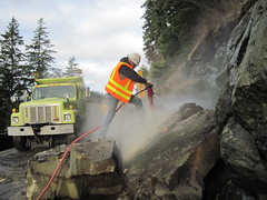
Drilling a rock on Chuckanut Drive
Originally uploaded by WSDOT.
This photo captures the essence of what our crews have been doing the last few days. Working long hours to make sure state highways remain open and safe to travel.
It all depends on the weather...
Posted by Unknown in national weather service, weather, winter weather on Friday, December 10, 2010
Forecasts call for heavy rain this weekend and our crews are gearing up in full force. They are out inspecting culverts, catch basins, flood gates, drains and anywhere that standing water may cause challenges for drivers. We have crews ready to work all weekend to keep roadways open during any storm.
The forecasts we see call for snow in the mountains from Saturday around 4 a.m to Sunday at 4 a.m. and then a warm up on Sunday. The freezing level could rise to as high as 8,000 ft., so much of that snow will melt and fill drains and rivers. We watch this closely because, as you may already know, if we get a ton of snow and it starts to warm up we may have to close highways for avalanche control late Saturday evening or first thing Sunday morning. Of course as we all about a fickle mother nature. This is only the forecast and can change.
Where do we get this weather info from? We get a detailed forecast several times per day from a private forecast service (WeatherNet). We use these forecasts, along with other sources such as the National Weather service, to help us determine staff levels and snow and ice-fighting material applications. We have a few other sources we like to reference and thought we would share them with you:
- National Weather Service
- Cliff Mass - has great explanations of not just what the weather forecast is but why it will be that way
- Ever wonder what the weather was like a specific day last month? Check out the weather history calendar offered by Weather Underground.
- University of Washington has several weather services that help tell the story
- Wilbur's Weather
- Atmospheric Sciences weather radar
- Probcast - a probabilistic weather forecast
Where do you like to get your weather info from?
AOTA Hosts Older Driver Awareness Week
Posted by Unknown on Tuesday, December 7, 2010
Senior Safety & Mobility is one of the AAA Foundation’s four strategic focus areas of research; we understand how important this issue is for seniors, their families and roadway safety overall. That’s why I was pleased to hear that the American Occupational Therapist Association’s (AOTA) is hosting Older Driver Safety Awareness Week this week (Dec 6th-10th). The goal of the week is to “promote understanding of the importance of mobility and transportation to ensuring older adults remain active in the community—shopping, working or volunteering—with the confidence that transportation will not be the barrier to strand them at home.”
This description is very similar with the Foundation’s goals when it comes to promoting senior driver safety. It’s important that both older drivers and their families understand what resources are available to help address this sensitive topic. When a teenager gets his or her driver’s license it is a big step towards becoming an independent young adult. The opposite feeling can occurs with older drivers as many seniors feel their independence is being threatened when it comes to giving up the keys. However, driver training tools like DriveSharp can help seniors retain some abilities critical to safe driving and when the time does come to give up the keys, options such as Supplemental Transportation Programs (STP) are available. The Foundation offers several free resources including an online senior evaluation tool, Roadwise Review Online, and a searchable license policy database containing current licensing policies for seniors in each state. Also, we recently redesigned and updated our most popular older driver brochure, Drivers 65 Plus. All of these resources, along with other useful information regarding seniors, can be found at seniodrivers.org and through AAA’s new senior driver website AAASeniors.com
Thanksgiving Recap: Mom gets her way
Posted by Unknown in holiday travel, traffic and travel on Thursday, December 2, 2010
There’s one mother who always gets her way. A mother that doesn’t seem to care about anyone’s plans, but her own. Yes, that’s her: Mother Nature.
And that was pretty evident over Thanksgiving weekend, when WSDOT’s traffic data shows 33 percent fewer drivers traveled over Snoqualmie Pass and 45 percent fewer traveled over Stevens Pass compared to the mild 2009 weather.
And those pre-Thanksgiving weather conditions, and lower travel numbers, weren’t just in the mountains. They also showed up in other places. On I-5 near the U.S./Canadian Border, there was a slight decrease (less than one percent) and through the Tacoma/Olympia area, there was a six percent decrease from 2009.
WSDOT tracks holiday travel in locations where travel increases significantly on long weekends. With its five-day break, Thanksgiving tends to see the most highway travelers of the year.
(Side note: let us know in the comment about your Thanksgiving route over the river and through the woods. We have the black and white data, but we're always looking for color commentary.)
In general, lower elevation areas saw decreased travel for the beginning days of the 2010 holiday weekend, and increased travel towards the end. This pattern also tends to favor weather as the key indicator, as the winter storm lost steam Thursday.
In the mountains, travel was down all weekend – as the snow hit hard most of the weekend, even into Sunday.
I-90 Snoqualmie Pass
For Wednesday through Sunday, 126,500 vehicles traveled I-90 over Snoqualmie Pass. This was a decrease of 62,800 vehicles (33 percent) compared to 2009.
- 11,400 fewer (25 percent) traveled Wednesday
- 8,700 fewer (36 percent) traveled Thursday
- 16,600 fewer (50 percent) traveled Friday
- 14,200 fewer (38 percent) traveled Saturday
- 11,900 fewer (24 percent) traveled on Sunday
US 2, Stevens Pass
For Wednesday through Sunday 17,100 vehicles traveled US 2 over Stevens Pass. This was a decrease of 14,200 vehicles (or 45 percent) compared to 2009.
- 2,100 fewer (38 percent) traveled Wednesday
- 1,500 fewer (41 percent) traveled Thursday
- 3,400 fewer (48 percent) traveled Friday
- 3,900 fewer (52 percent) traveled Saturday
- 3,200 fewer (44 percent) traveled Sunday
I-5, Bellingham to Canadian border
For Wednesday through Sunday, 139,800 vehicles traveled I-5 between Bellingham and the Canadian border. This was a decrease of 200 vehicles (less than one percent) compared to 2009.
- 607 fewer (2 percent) traveled Wednesday
- 5,000 fewer (23 percent) traveled Thursday
- 600 fewer (2 percent) traveled Friday
- 2,900 more (10 percent) traveled Saturday
- 3,100 more (11 percent) traveled Sunday
I-5, Olympia to Tacoma
For Wednesday through Sunday, 522,000 vehicles traveled I-5 between Olympia and Tacoma. This was a decrease of 35,600 vehicles (6 percent) compared to 2009.
- 24,500 fewer (18 percent) traveled Wednesday
- 4,800 fewer (5 percent) traveled Thursday
- 7,900 fewer (7 percent) traveled Friday
- 700 more (1 percent) traveled Saturday
- 1000 more (1 percent) traveled Sunday
November 22nd winter storm response...
Posted by Unknown in winter preparedness, winter storms, winter weather on Monday, November 29, 2010
By guest bloggers Jeff Switzer and Bronlea Mishler
Putting a Face Behind Traffic Statistics
Posted by Unknown on Wednesday, November 17, 2010
Like many industries, transportation officials use statistics to show current trends or to illustrate the scale of certain issues. For instance, earlier this year the Department of Transportation reported that traffic fatalities fell by 9.7% from 2008 to 2009, reaching the lowest death toll since 1950. The reaction by most people reading that statistic is undoubtedly positive because it shows a downward trend in road fatalities. However, the statistic that needs to be mentioned is that despite the trend, 33,808 people still died on U.S. roads in 2009. This is an outrageous number of deaths and we need to remember that numbers like 33,808 is not just a statistic. These are the family members and friends of Americans from accross the country.
This is why I was pleased to read about the DOT’s new video series, Faces of Distracted Driving, on Secretary Ray LaHood’s blog. This campaign helps tell the stories of those who have been personally affected by the issues of distracted driving. Last year, nearly 5,500 deaths and another 500,000 injuries resulted from crashes involving distracted driving. Statistically speaking, 5,500 may sound small, but after hearing the stories of those who’ve been affected, I guarantee these numbers won’t seem like just another statistic. Distracted driving is a dangerous driving behavior and it’s up to all drivers to individually take responsibility for their actions to make our roads safer.
Looking at new ways to present traveler information...
Posted by Unknown in map, traffic and travel, Website on Tuesday, November 16, 2010
We are always looking for ways to improve the travel information we offer on our website to help you make the most informed decision and know before you go. Recently, new technology is available that gives us new ways to display traffic conditions to you.
We'd like to show you what we have been working on internally and hope you'll take the time to let us know what you think. On this new "alpha website," we have taken most information from our existing traffic website and put it on what we call a "slippery map." (We are calling it alpha, because we don't think it's ready for a beta just yet.) This "slippery map" is one that you can pan and zoom into, to see everything that could be happening on your route to make a truly informed travel decision before you leave.
Let us know what you think of this new website by leaving a comment in the comment area below. We know it isn't quite finished yet, we have a few things that were left out because we want to check with you to make sure this is the direction that we should be going..
Some things we would like you to think about while using the map
- Does it give you a better picture of the traffic conditions on roadway?
- Is it harder/easier to find your route home?
- How is the navigation speed of the map?
- Do the layers of information load quickly for you?
There are many unknowns with a site like this and our focus while you are browsing is to collect some metrics. We need to make sure this site will handle the amount of spiking web traffic we get when it snows or have inclement weather in the Northwest. We average around 700,000 page views per day in the summer months and that number moves up to 1 million page views per day in the winter months. When it snows in the greater Puget Sound area that number can go as high as 6 million page views per day. We know that there is nothing more frustrating than a website that is not available when you need it and we want to make sure that no matter what direction we go our website can handle the demand.
Thanks for taking the time to check this site out and offering your feedback, we appreciate it.
Without further ado here is a link to our Alpha Traffic and Travel information website.
(Please leave feedback by clicking on comment icon on top right of this story.)
Heading over I-90 Snoqualmie Pass? Keep your eyes peeled for critters big or small
Posted by Unknown in snoqualmie pass, wildlife on Friday, November 12, 2010
by guest blogger Meagan Mcfadden
The next time you head over I-90 Snoqualmie Pass, keep your eyes peeled for critters big or small. Your sightings can help identify where animals are trying to cross I-90.
You may be wondering how you get this information to the appropriate people. Well, it’s easy. The Western Transportation Institute and Conservation Northwest recently launched I-90 Wildlife Watch, a citizen-based monitoring program that invites you, the I-90 traveler, to report wildlife sightings along I-90 from North Bend to Easton. There is no animal too small to be counted; Wildlife Watch encourages you to log in all sightings, whether alive or dead. The website asks travelers to identify where they saw the animal.
This logging of animal sightings complements other wildlife monitoring work being conducted by us as part of the I-90 Snoqualmie Pass East Project. We plan to use the information logged by travelers and the other monitoring programs to determine which species of wildlife are trying to cross the interstate. This will allow us to determine where to build wildlife crossings as part of the project and to assess the ultimate effectiveness of the structures after they have been built.
Signs, signs, everywhere there's signs...
Posted by Unknown in election, highway advertising, road sign on Tuesday, November 9, 2010
It was great to see the media coverage from the news release sent Friday (Nov. 5) reminding property owners it’s time to remove temporary political signs visible from state highways.
The signs need to be down by Friday, Nov. 12.
The folks in WSDOT’s Outdoor Advertising group are responsible for making sure Washington is in compliance with state and federal highway advertising laws. The Highway Advertising Control Act “declares that sign control adjacent to state highways is necessary to assure that information of interest to the traveling public is presented safely and effectively, and to conserve the natural beauty of our roadsides.”
Part of the state’s role in highway advertising is outlined in Washington Administrative Code (WAC) 468-66. This WAC is where you can find the regulations for temporary political signs on private property visible from state highways. First, property owners must consent. Then the signs,
- must be removed within 10 days following the election (that’s Nov. 12, 2010)
- can only reach a maximum size of 32 square feet in area, and
- must comply with any local regulations.
Remember, no signs (other than those used for traffic control) are allowed within the state right-of-way. None – that includes retail, political, garage sale, etc. Why? Both safety and scenic issues. The WSDOT website provides more information about Washington’s outdoor advertising regulations.
Here are some basic clues on how to tell if a location is within a state highway right-of-way:
- Utility poles are typically located inside the right-of-way. So no signs on the pole or between the pole and the state highway.
- Many locations also have a fence line separating the right-of-way from private property. So again, no signs on the fence or between the fence and the state highway.
If you have question about Outdoor Advertising, contact Pat O’Leary. He can be reached at OLearyP@wsdot.wa.gov or by calling 360-705-7296. If your question is about a specific area, be prepared to provide the state route number (I-5, SR 28, US 2, US 97, etc.) and the name of the nearest intersection or approximate milepost.
So no signs in the right-of-way - none, ever. And if you do get permission to post them on private property, it's time to take them down for the season.
Reached a milestone on Flickr...10 million views
Posted by Unknown in flickr, milestones, photos on Monday, November 8, 2010
Over the weekend we reached a milestone on our Flickr account; we surpassed 10 million views! It's quite astounding really.
Since April 2007, we've uploaded more than 12,000 photos. We first started uploading photos in preparation for the Tacoma Narrows Bridge opening celebration. Since then, we have found the account to be tremendously useful in telling our story.
Here's a fun compilation of some of our favorites - note the wide variety of photos:
#1 - First photo shared - April 13, 2007 Tacoma Narrows Bridge expansion joint
The trailer needed to haul this expansion joint across the state was enormous, here is what the joint looks like in place on the bridge.
#2 -Tacoma Narrows Bridge opening celebration - July 15,2007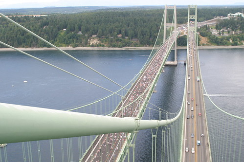
We posted photos from the bridge on the day of this event, and that event started what you see today with the regular posting of photos by our staff. We were very excited to have Darth Vader join us: He probably just wanted to see what successful construction looks like.
#3 - I-5 in Chehalis closed due to flooding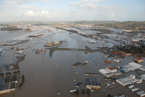
I am still stunned by the power of the water in this photo. In December of 2007, I-5 in Chehalis was completely submerged for several days.
#4 - Snow Donut on North Cascades 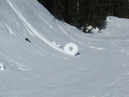
This photo was published nationally and internationally. We found it amusing when the photo showed up in The Sun in the United Kingdom comparing their football coach to this snow donut.
#5 - Lewis and Clark Bridge Inspection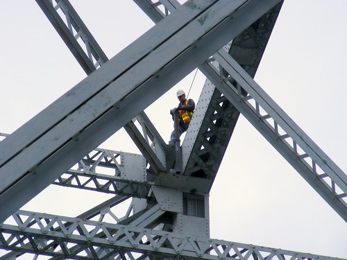
One of our employees was tagging along with a bridge construction crew in July 2008 and happened to snap this photo of the bridge inspector on the Lewis and Clark bridge.
There are others that didn't make this list that are worth mentioning, like a photo of a ferry in front of a sunset, the bunny that chased the snowplows, the pika, the bobcat, a large rock in the road, buses dangling over a free way and so many more you'll have to see for yourself.
Thanks for helping us reach such an incredible milestone. We appreciate your views, comments and questions. We look forward to sharing more transportation related photos with you.
Drowsy Driving
Posted by Unknown
People underestimate the dangers of drowsy driving, but driving while fighting the urge to sleep puts everyone on the road at risk. Sadly, a new analysis of National Highway Traffic Safety Administration crash data estimates drowsy driving is a factor in nearly one in six fatal crashes. As recently covered by the Good Morning America, CNN, USA Today, the New York Times and others, the AAA Foundation recently published a study showing that two out of five drivers surveyed (41 percent) admitted to falling asleep behind the wheel at some point. In fact, just recently in Maryland two highway workers were killed by a drowsy driver in the middle of the day.
In recognition of Drowsy Driving Prevention Week®, sponsored by the National Sleep Foundation, the AAA Foundation is calling attention to the serious issue of driving drowsy. Just like drugs and alcohol, sleepiness can impair important functions behind the wheel like response time, awareness and judgment. Many people think they can force themselves to stay awake, but science shows us that isn’t always the case, and dozing off behind the wheel, even for a few seconds, is plenty of time to drive off of the road or over a centerline.
AAA offers some helpful tips from the Foundation’s brochure, How To Avoid Drowsy Driving, include:
• Get plenty of sleep (at least six hours) before a long trip;
• Travel at times when you are normally awake or stay overnight rather than driving;
• Schedule a break every two hours or every 100 miles;
• Stop driving if you become sleepy;
• Do not plan to work all day and then drive all night;
• Drink a caffeinated beverage;
• Avoid driving during sleepy times of day; and
• Travel with an awake passenger
Fish love our new bridge on Mount Baker Highway
Posted by Unknown in culvert, fish, Mount Baker Highway on Friday, November 5, 2010
It didn’t take long for fish to find their way back to Chain-up Creek once the barriers were removed.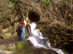
For years, a small concrete culvert and steep drop-off made it nearly impossible for fish to return home.
But a brand new bridge along Mount Baker Highway has revived Chain-up Creek and made the journey home to native habitat easier for spawning fish.
Fish have already been spotted and photographed swimming in the creek only a month after WSDOT completed work on the new bridge and reopened the creek.
During construction, crews were careful to rebuild the creek bed. We strategically placed all the boulders, rocks and logs to mimic and foster the natural flow of a creek. And it’s paying off.
We worked all summer to shift a half-mile stretch of Mount Baker Highway away from the Nooksack River and build the new bridge at Chain-up Creek. We recently opened the new bridge, several miles east of Glacier, to traffic.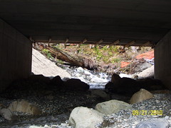 It’s not just the fish who benefit from the new bridge, either. These improvements will make a big difference to drivers and residents in the area. The new bridge and rebuilt creek will reduce the risk of flood damage to the road and reduce the potential for emergency road closures. They should prevent costly emergency repairs and repeated lane closures. It’s a win-win for drivers and the environment.
New US 2 west Stevens Pass traffic camera on line
Posted by Unknown in cameras, stevens pass, US 2 on Wednesday, October 27, 2010

By Guest Blogger Jeff Adamson
The newest addition to the traffic camera images available on our website offers you another eye on Stevens Pass traffic conditions.
The new camera is on top of the Variable Speed Limit sign that we installed last year, about 2-1/2 miles below the summit on the west side of the pass. That’s about a half mile below the Old Faithful Avalanche zone (that’s where we have the two M-60 tanks pointed - where most of the winter avalanche control is necessary). That’s also the steepest (5-6%) grade on the pass. It is where most trucks and cars get stuck. Typically that is due to one of two reasons:
- Those who stop to pick up hitchhiking snowboarders who slid down the avalanche chutes (DANGEROUS) and want to get back to the ski area, so they can do it again, or
- Those who figured out they shouldn’t have ignored the signs and stop in the middle of the lane to put on their chains (and cause a chain reaction of cars that had to stop and can’t get started again).
It makes it pretty obvious why we wanted a camera there – it gives us and the State Patrol a new tool so we can respond more quickly and with the right equipment and crew members to deal with whatever is happening (an avalanche, slick pavement, a collision, stuck cars or a sideways semi). Besides the new camera, the original Stevens Pass camera that’s been on the web for a dozen years, moved last Friday, and so did the view it provides.
You may recall that we’re building a pedestrian bridge over the highway at the summit. It’s almost done and the old location of the camera and weather station on the shoulder of the highway at the west end of the ski area parking lot is now under several tons of concrete and steel – the north bridge support and ramp.
The weather station building with the tower on top where the camera is located got moved several hundred yards to the east end of the ski area parking lot, next to the highway shoulder. As a result, the camera is now facing the opposite direction from where it used to. It points back (west) toward the summit showing the pavement, the parking lot and the new bridge. For our maintenance staff, those are the things they need to monitor, but it can be a little confusing since the west view camera that we added a couple years ago is (obviously) also pointed west. (It’s located under the eave on the west side of the Stevens Pass Ski Lodge and shows the pavement and the ski area parking lot on the southwest side of the highway.) It also now shows the new right turn lane into that parking lot that we also built this summer. That has been a problematic (read “get stuck here”) access for years so our plow drivers, Incident Response Team members, State Troopers and ski area parking crew members are all looking forward to a winter without the spinouts and stoppages, there.
Back to the cameras – they update every minute and here are the links:
- Stevens Pass page: http://www.wsdot.wa.gov/traffic/passes/stevens/#
- Old Faithful camera: http://www.wsdot.wa.gov/traffic/cccam.aspx?cam=9145
Check out the new camera and bookmark it if you’re Stevens Pass skier, since the slopes should be ready for you by Thanksgiving.
Tolling starts on the SR 520 bridge in spring 2011: How will you pay the toll?
Posted by Unknown in Good to Go, Tolling on Monday, October 25, 2010
by guest blogger Emily Pace
 You might have heard that all-electronic tolling on the SR 520 bridge begins in spring 2011. This means there will be no toll booths, no stopping and no hassles.
Not familiar with Good To Go!? It’s Washington state’s electronic toll collection system that lets you pay tolls without stopping. It’s the easiest and cheapest way to pay your toll. Drivers with Good To Go! passes will have the amount deducted from their prepaid account as they drive across the bridge.
To give drivers more options, we recently announced new Good To Go! toll passes. There’s a wide range of options available, from a permanent sticker to movable and specialty passes. Check out the new passes and get more information including prices.
Once you buy a pass and set up an account you’ll be able to use it on the Tacoma Narrows Bridge, SR 167 HOT lanes and SR 520 bridge next spring.
We’ll photograph the license plates of those who don’t have a Good To Go! account and send a toll bill in the mail to the registered owner.
While toll rates for the SR 520 bridge have not been set, you can take a look at range of toll rates being considered (pdf 123 KB). Tolls will vary by time of day and you’ll pay the lowest toll rates if you have a Good To Go! account. The Washington State Transportation Commission will make a recommendation on toll rates later this fall, and a decision is expected in early 2011. Watch for public hearings to share your thoughts on the proposals.
To give drivers an alternative to paying the toll, King County Metro and Sound Transit have started adding nearly 130 bus trips a day across the SR 520 bridge. These service enhancements, along with park-and-ride and bus stop improvements, will give you more travel options when electronic tolling begins in spring 2011.
So, now that you know your options you have some time to think about what works best for you. Starting in January we’ll begin offering incentives to sign up. Be among the first to know about the special offers by signing up at for e-mail updates.
Let us know what you think of the new Amtrak Cascades advertising campaign
Posted by Unknown in advertisement, Amtrak Cascades, rail on Thursday, October 21, 2010
We’ve launched a new advertising campaign for Amtrak Cascades this fall. The “Verbs” campaign is designed to educate people about the benefits of train travel and highlights the wide variety of things people are able to do on a train, but are difficult or impossible to do with other forms of transportation. Each element
 |
| Example of an ad you may see as part of this campaign, "Tweet to Vancouver B.C." |
The ads are out in the Seattle, Portland, and Vancouver, B.C. metro areas and you can see them locally here in Seattle on Sounder trains, Sound Transit Link Light Rail, outdoor billboards (downtown Seattle billboard tri-vision at Valley & Fairview), and on-line at KING 5 news, Weatherbug, and KOMO News.
 |
| Newspaper Ad |
Let us know what you think about the new campaign!
UPDATE: Wi-Fi is coming on-line on board Amtrak Cascades in December. We are finishing up the testing phase to make sure it is working correctly and will launch the service as soon as that is completed. So you will be able to YouTube, Skype, Tweet and more on Amtrak Cascades!
Parents and Teens Driver Study
Posted by Unknown on Friday, October 15, 2010
The AAA Foundation released a major report on Parents and Teen Drivers this past Tuesday. This was the first naturalistic study that observed the interactions of parents and teen drivers during the learner stage of driving using in-vehicle cameras which were mounted the dashboard. The study found that while many parents do a good job of providing good advice, the wasn't enough practice time overall and specifically there wasn't enought practice in different conditions such as heavy traffic, incliment weather or driving at night. This is an important message for parents of teen drivers to hear because there is absoulutely no substitute for practice when it comes to driving. Footage from our study was used by a variety of news shows including on NBC's Today Show and ABC's World News with Diane Sawyer.
We still need your votes for the America’s Transportation Award
Posted by Unknown on Tuesday, October 12, 2010
A year ago a landslide destroyed a stretch of SR 410 and now our work to reopen the roadway is being recognized nationally! The Nile Valley Landslide project is one of ten transportation projects selected by AASHTO (American Association of State Highway Transportation Officials) as a finalist for this year’s Best Transportation Project in the U.S.
What we need from you is to continue to vote so we can win the “People’s choice Award.” This award is solely based on the number of votes we receive. Currently, we are one of the top two projects. In order to win $10,000 to give to the local community who was incredibly impacted by the landslide, we need you to head over to the America’s Transportation Award website and cast your vote. Feel free to cast your vote every day as many times as you want. Help us win this thing!
Employees on Temporary Layoff October 11...
Posted by Unknown in furlough, temporary layoff on Friday, October 8, 2010
Due to state budget reductions, we will be closed on Monday, October 11, and employees will be on temporary layoff status. Regular service will resume on Tuesday, October 12. See you Tuesday.
Walk to School Day
Posted by Unknown in walk to school, walking on Tuesday, October 5, 2010
By guest blogger Charlotte Claybrooke
Think fresh, brisk air, a chance to get outside, early morning and a backpack. Do you remember walking or biking to school as a child? My most recent memories are from when I biked with my son to school.

Walking and bicycling to school happens throughout the school year but Walk to School Day celebrations are designed to make this retro activity more festive. The combined effect of childhood obesity, traffic congestion, environmental pollution and rising fuel prices have lead to schools and families rethinking how children will take the daily trip to school. They have embraced the concept and are using funds from sources like the Safe Routes to School Program to help increase the number of children walking and biking to school safely all year. For more information about the Safe Routes to School Program go to http://www.wsdot.wa.gov/localprograms/saferoutes/.
Walk to School Day is not a new initiative. In the U.S., it started in Chicago in 1997, modeled after the United Kingdom’s walk to school events. This year Walk to School Day is expected to include 5,000 schools from all 50 states. Walkers from the U.S. will join children and adults in 40 countries around the world.
Here is a list of some schools participating in Walk to School Day Celebrations in Washington:
| School Name | School City |
| Sherwood Forest elementary school | Bellevue |
| Lincoln elementary school | Ellensburg |
| Ben Franklin elementary school | Kirkland |
| Peter Kirk elementary school | Kirkland |
| Juanita elementary school | Kirkland |
| Lakeridge elementary school | Mercer island |
| Edward Zeiger elementary school | Puyallup |
| Firgrove elementary school | Puyallup |
| Rock Island elementary school | Rock island |
| Elizabeth Blackwell elementary school | Sammamish |
| Epiphany school | Seattle |
| Sacajawea elementary school | Seattle |
| John Muir elementary school | Seattle |
| Concord elementary school | Seattle |
| West Woodland elementary school | Seattle |
| Lawton elementary school | Seattle |
| Adams elementary school | Spokane valley |
| Suquamish elementary school | Suquamish |
| Mccarver elementary school | Tacoma |
| Washington elementary school | Vancouver |
| Adams elementary school | Veradale |
| White center heights elementary school | White center |
I enjoyed biking my son to school because it gave us something fun to do together in the mornings. It was also a great way to wake myself up before the work day. Whatever the motivation, Walk to School boils down to support for healthier families and safer communities.
For more details and to see who’s walking this year, visit www.walktoschool.org.
WSDOT recognizes October as Community Planning Month
Posted by Unknown in community design, community planning on Monday, October 4, 2010
By guest blogger, Paula Reeves, AICP and Co-chair of APA Washington’s Community Planning Assistance Program
We don’t cut the ribbon on a community planning document in the same way we celebrate the opening of a new bridge or highway. However, as a Certified Planner working for WSDOT, I have seen proof that these community planning processes make a significant difference in transportation and in our cities, towns and communities. This month we are joining the American Planning Association in recognizing October as Community Planning Month.
So what exactly is community planning? Community transportation plans help to identify affordable short-term improvements like signal timing adjustments, new crosswalks, and better signage. These plans also help by creating long-term visions and action plans for some of our most congested corridors. They tie all the different parts and pieces of our system together like county roads, city streets, rail, highways, ferries, buses, sidewalks and trails. During a recent community planning process I held with Washington APA in Cle Elum, residents envisioned a more walkable downtown by re-designing State Route 903. Working together with other planners, architects and engineers, we generate a concept based on their ideas. Our work produced a common vision and identified steps to construct it.
I think of community planning as being a lot like mediating family disagreements – only with more people, more disagreements, and a short timeline. During these planning workshops, I work with groups of neighbors, elected officials, business owners and others to find common ground and build an action plan for making it happen.
Community planning saves money by uncovering efficiencies and bringing to light information that may not have otherwise been considered – things like freight patterns, school traffic, planned developments, local preferences, and the list goes on. Another example comes from Woodland, WA. During development of a community plan, residents found that roundabouts at the intersection of a local street and highway off-ramp would reduce traffic congestion, while at the same time create the entrance they wanted for their downtown. This improvement could save millions by eliminating the need for a much larger intersection improvement they originally thought was needed.
At whatever scale and whichever agency leads the process, community planning helps jump start short term projects, support sustainable economic development, uncover efficiencies, and even identify funding partnerships. Help us out during Community Planning Month by sending your recommendations or vision for transportation in your community to WSDOT Community Design at Reevesp@wsdot.wa.gov or by calling 360-705-7258.
You can also participate in your local community planning processes by contacting your local elected officials or your city or county administrator’s office.
Find out more about our nationally recognized Community Transportation Planning and Design by visiting these websites: FHWA Livability in Transportation Guidebook (pdf) - (posted on the AASHTO website)
Having a blast on I-90 Snoqualmie Pass
Posted by Unknown in explosions, I-90, rock blasting, snoqualmie pass on Thursday, September 30, 2010
by guest blogger Amanda Sullivan
At the start of summer, we posted a video of one of our test blasts to give you a small taste of what would happen over the summer on I-90 east of Snoqualmie Pass. Over the past couple of months, crews have gotten into a nice rhythm and have been performing much larger blasts called production blasts. These larger blasts sometimes mean more time is needed to clean debris from the interstate and inspect the slopes. We wanted to show you all what goes into the rock blasting operations, from preparing the slopes, cleaning the road of debris, and, of course what everyone wants to see…the blast. It’s a carefully orchestrated event from the time crews drill the holes early in the morning to when the loaders are clearing the road of debris and our geotechnical experts are inspecting the slopes for stability later that night. We do everything possible to reduce risk and keep drivers and our construction crews safe. So, put on your hard hat, safety vest, glasses and boots and spend a day in the life of our controlled rock blasting crews.
Crews are conducting rock blasting operations on the slopes adjacent to I-90 near the Lake Keechelus Snowshed (milepost 58) in order to widen the highway from four to six lanes. This means temporary one-hour closures of I-90 at 6 p.m. every Monday through Thursday. Due to the uncertain nature of rock blasting, the blasting closures could last longer and are subject to frequent schedule changes. We suggest you check our What’s Happening on I-90 Web page for up-to-date information on controlled rock blasting schedules and other construction impacts. Crews will complete blasting and excavating the tons of rock from the slopes by the end of October.
Help end the frustration on SR 3, don’t block residential driveways
Posted by Unknown in driveways, Hood Canal bridge, SR 3 on Friday, September 24, 2010
by guest blogger Joe Irwin
Having personally been stuck in the traffic backups caused by the Hood Canal Bridge countless times, both heading to and coming from the Olympic Peninsula, I can attest that they’re pretty much a way of life for residents and visitors to the area.
But, like traffic jams the world over, they’re also about as fun as a root canal without Novocain.
Over the years, it’s come to my attention that while sitting in traffic on SR 3 is bad enough for motorists, it can be even worse for homeowners who live along the northbound lane of the highway. Imagine that you’re four car-lengths from home and can’t get there because the bridge is open, traffic is backed up and some other motorist has blocked your driveway. Or that you have tickets to a show in Seattle, and have to catch a ferry, but can’t leave your house because a semi is blocking you in.
Frustrating? You bet.
Some North Kitsap residents have experienced this sort of frustration day-in and day-out for years, decades even.
 |
| Hash marks designate "do not block" zones |
Is it illegal to stop your car in front of these driveways? No. But we’re hoping these signs and markings will serve as constant reminders to SR 3 motorists to be good neighbors to residents who live along the highway. They’ve put up with this issue for years, after all.
Let’s help them out… and into their driveways.
DOT hosts Distracted Driving Summit; Foundation to host Heads Up Driving Week
Posted by Unknown
Earlier this week I attended the Distracted Driving Summit hosted by Department of Transportation and Secretary Ray LaHood. The summit featured a wide cross section of the transportation community but it was clear that everyone had a shared goal – stop distraction on our roads. In support of the summit, the AAA Foundation released new distracted driving statistics from our Psychological Foundations of Safety Culture study and 2010 Traffic Safety Culture Index survey which found that fifty-five percent of drivers feel less safe than they did five years ago with the main reason being distracted driving.
Similar to previous surveys, the results showed that drivers understand the risks associated with talking and texting while driving, yet many continue to engage in this dangerous behavior anyway. In fact, motorists rated texting while driving (88%) equally as dangerous as drinking while driving. While I’m glad to hear drivers are beginning to understand the seriousness of distraction, the “Do as I say, not as I do” attitude is still an obstacle we must overcome to improve safety. This is precisely why next week the AAA Foundation and AAA are urging drivers to commit to seven days of distraction-free driving during the second annual Heads Up Driving Week Sept. 26 to Oct. 2. During this week, we are calling on all motorists to drive distraction free, “Try it for a week, do it for life.”
Smarter Highways 102: Variable Speed Limits
Posted by Unknown in I-5, Smarter Highways on Tuesday, September 21, 2010
by guest blogger Annie Johnson

With Smarter Highways live on northbound I-5 in south Seattle and activation on SR 520 just around the corner later this fall you’ve mastered the basics. You know that the yellow merge arrows are going to help you around the blocked lane and that a red “x” is telling you that a lane is closed. Now it’s time for what we like to call Smarter Highways 102: variable speed limits.
It’s about what’s ahead
Just like the symbols, the speeds displayed on the overhead electronic signs warn you about what’s happening on the road ahead of you. Congestion on the highway ebbs and flows and the variable speed limit signs reflect that fluctuation. It’s just like a driver speeding up and slowing down to adjust to the traffic flow. The only difference is that the Smarter Highways signs let you know in advance that the speed change is coming.
Speed limits reflect the conditions
The electronic speed limits displayed on the signs reflect travel conditions not necessarily how fast or slow traffic is moving in the freeway lanes. If traffic is stopped, the signs will display the system’s lowest speed, 40 mph. The signs won’t show a lower speed limit, even if traffic is moving slower.
Think of the signs just like a regular static speed limit sign. It’s the maximum speed you should travel, however as any driver knows you might have to drive slower than the posted speed limit due to traffic or weather. Also, just like a static sign the speed limits are enforceable and you could be ticketed by law enforcement for exceeding the posted speed limit.
Helping drivers travel safer and smarter
Ideally, approaching traffic will slow down and pass through the problem area at a slower but more consistent speed reducing stop and go traffic. By reducing stop and go traffic we’re also reducing the probability of an accident by giving drivers more time to react to changing road conditions. This helps drivers avoid the need to brake sharply as they approach congestion.
So how do you come up with that speed?
In urban areas traffic sensors along the roadway collect vehicle speeds, congestion information and traffic flow rates. This information is continuously relayed back to our Traffic Management Center in Shoreline and analyzed by computers. When circumstances that would benefit from lowered speed limits—like congestion—are identified, the computer reduces speeds incrementally to gradually reduce the approaching flow of traffic to the congested area. This is different than the electronic speed limit signs you see on I-90 over Snoqualmie Pass and on US 2 over Stevens Pass. These signs are manually operated by our South Central and North Central region Traffic Management Centers to reflect the current road and weather conditions on the passes.
So there you go. That’s Smarter Highways 102. Any questions?
Highway 202 at Tokul Creek: Flood repairs in time for winter 2010
Posted by Unknown in creek, environment, fish, flood, SR 202, Tokul creek on Tuesday, September 14, 2010
by guest blogger Jamie Holter
Scenes like this made the news in January 2009

But something else was happening near Highway 202 between Fall City and Snoqualmie. Tokul Creek, swollen by the sheer volume of water, changed course and, rather than meandering nicely under Highway 202, it redirected itself and began to erode the riverbank, leaving the banks and the local road unstable.
Engineers are now concerned that heavy fall rain in 2010 will push more debris up against the old concrete piers that support a bridge that’s no longer there.
The debris plugs the water flow and it backs up eroding the bank which can lead to more damage.
During the first week of September, contractor crews from Amir Ahmadi’s Project office began work on a bridge scour repair job on Tokul Creek.
Over the next month, under emergency permits from the Department of Fish and Wildlife and the Army Corps of Engineers, dozens of workers will be on site to remove large amounts of wood and debris trapped near the bridge. They will remove the old concrete bridge piers and armor the new existing bridge piers with large rocks.
But it’s not that easy. You don’t just come in with bulldozers. Biologists are on site to trap and relocate fish. They use this porous curtain to let water pass through but not the fish.

This rainbow trout was one of the first caught and taken downstream.

Then we install something called an aqua dam, a large inflatable filled water to make the area downstream fish and water-free. Pipes installed in the area take the water around the aquadam to a place downstream and out of our work area.
Here is a wide shot of a full inflated aquadam. Isn’t it strange looking?

Over the next few days we will get to work removing debris and hauling in ecology blocks, large light-weight lego-looking type barriers to shore up the existing bridge piers.

Stay tuned and we will provide more about the progress of this project on SR 202.
Decline in Traffic Deaths A Step In the Right Direction
Posted by Unknown on Thursday, September 9, 2010
The Department of Transportation just announced roadway deaths are the lowest they’ve been in 60 years despite an increase in the number miles driven. Statistics show that traffic deaths fell by 9.7% from 2008 to 2009 and the 33,808 deaths is the lowest since 1950. The decline is a clear signal of the hard work being done by to change our traffic safety culture. Increased seat belt usage, safer road designs and stronger enforcement of laws are all contributors to the decline. However, we have to keep in mind the most important fact – 33,808 people still died on our roads last year and that’s still an outrage. I'm pleased that 3,600 fewer people died in 2009, but there are still issues that threaten our safety on the road. Distracted driving is a major problem that will get worse as new in-vehicle technologies are developed. Cell phones, GPS navigation systems, other passengers and pets are all potential distractions and taking your eyes off the road for one second is all it takes to cause a crash. I think Secretary LaHood’s reaction to this news sums things up well, "We could not be happier, but we are not going to sit back on our laurels. We have a long, long way to go."
Americas Transportation Awards, we need your help....
 |
| Aerial photo of SR 410 landslide |
What could we win, you ask? The winner receives $10,000 to donate to support a community service project or local charity. Our hope is to put the money back into the Nile Valley community.
So why are we telling you? This particular award is the "People's Choice Award" and the winner is based solely on the number of votes received. We hope you can take the time today, and maybe everyday, to head on over to the America's Transportation Award website and cast your vote and help a local community who was so incredibly impacted by this landslide.
Still not convinced you should vote? Here are a few more reasons:
- This is the only project on the west coast that was nominated
- It's a way to honor those who worked so hard to get this road back open, we're talking 14 hours a day seven days a week to construct a new river channel and get a detour set up.
- $10,000
- Did I mention that $10,000 would come to Washington state to benefit a local project or charity?
 | |||
| Scan this Microsoft Tag with your smartphone tag reader to vote. |
(feel free to vote up to 10 times per day ;) )
Labor Day 2010: The Recap
Posted by Unknown in holiday travel, labor day, mountain pass on Wednesday, September 8, 2010
While it didn’t quite reach the 10 percent AAA predicted, travel increased in most locations compared to Labor Day weekend 2009. I have no idea why we didn’t reach the 10 percent mark. The weather remains one theory. What’s yours?
Yes, those ferry boats were full. There was a backup on I-90 coming back into the Puget Sound area and through Olympia into Tacoma. But we have seen those most every weekend this summer. And the I-90 backup was stop-and-go, not the stop-and-stop we typically see on busy three-day weekends.
So, what’s the deal? One piece of happy news could be the answer. It seems there were no major traffic incidents at the locations we track for holiday travel. That alone kept traffic moving rather well.
Thanks. And, here are the official numbers.
Over I-90 Snoqualmie Pass, there was a slight increase in traffic volumes over Labor Day compared with 2009. Between Friday and Monday, 191,000 vehicles traveled both directions of Snoqualmie Pass, an increase of 4,000 vehicles, or 2 percent.
- 53,900 traveled Friday, with 200 (less than 1 percent) more vehicle traveling this year.
- 43,900 traveled Saturday, with 1,700 (4 percent) more vehicle traveling this year.
- 42,800 traveled Sunday, with 800 (2 percent) more vehicle traveling this year.
- 50,000 traveled Monday, with 1,100 (2 percent)
We also tracked traffic in three other locations. In comparison to 2009, on I-5 from Shoreline (north Seattle) to the U.S./Canadian border (for Friday through Monday) there were 140,700 vehicles on I-5, an 11,000 vehicles (or 9 percent) increase compared to 2009.
- 2,200 more (6 percent) traveled Friday.
- 2,900 more (9 percent) traveled Saturday.
- 3,500 more (11 percent) traveled Saturday
- 2,300 more (8 percent) traveled Monday.
There’s an equipment malfunction so no data on I-5, Olympia to Chehalis (Thurston/Lewis county line), but we can tell you what happened further north, between Olympia and Tacoma. We found the traffic was fairly normal for a summer weekend. And the volume was essentially unchanged compared to the same period in 2009. For Friday through Monday there were 446,000 vehicles on I-5. This was an increase of only 1,100 vehicles (0.2 percent) from 2009.
- 5,300 fewer (4 percent) traveled on Friday.
- 2,700 more (2 percent) traveled on Saturday.
- 6,400 more (7 percent) traveled on Saturday
- 2,700 fewer (3 percent) traveled on Monday.
We were unable to gather data for westbound US 2/Leavenworth to Stevens Pass this holiday weekend. For Friday through Monday there were 16,700 vehicles on eastbound US 2. This was an increase of 2,200 vehicles (or 15 percent) compared with the same period in 2009. And while this seems like a large jump, we didn’t have any backups Monday on westbound US 2 coming back.
Another hmmmmmmm. What’s your theory?
Tacoma Narrows Bridge Repair
Posted by Unknown in crack, fracture, steel beams, tacoma narrows bridge on Friday, September 3, 2010

Monitored Fracture
Originally uploaded by WSDOT.
Here's the reason the westbound lanes of the old Tacoma Narrows bridge was down to two lanes yesterday. Crews worked through the night to repair this fractured steel beam. More photos on our Flickr site.
What happened to the US 2 - Stevens Pass Traffic cameras?
Posted by Unknown in cameraseras, stevens pass, US 2 on Wednesday, September 1, 2010

by Guest Blogger Jeff Adamson
Construction began this past May on the US 2 - Stevens Pass Summit - Pedestrian Safety project, which will provide a separated pedestrian crossing to eliminate conflicts with motorists. It also will install access control barrier to prevent pedestrians from walking across the roadway and a right turn lane into the ski facilities western parking lot. Since the project started, the outside eastbound lane has been closed because part of the project builds a new right turn lane into the parking area on the west side of the summit. That lane is finished now and on Wednesday, September 1st, we're going to move the concrete barrier off the highway. The new lane stripes will be painted so by the end of the day on Thursday- the outside lane will be reopened to traffic. The timing worked well so there won't be any lane restrictions over the Labor Day weekend.
The timing that didn't work out quite so well involves the Stevens Pass traffic cameras. They're critically important in the winter, but for the most part, they're only value in the summer is "recreational" for hikers, mountain bikers and the like to see what the weather is like. The only times they have much travel value is on holidays. So here we are the week before Labor Day and the cameras and weather station had to be unplugged, and they'll stay dark for next two weeks. The building that houses all the electronics is right where the end of the new pedestrian bridge ramp is being built. The new location for the control building is several hundred yards further east. It would have been nice to be able to delay moving it until next week, but the construction schedule is extremely tight to get the project substantially complete (usable) before it gets too cold for concrete to set. So the ramp work required the building to be moved today. (With all the lanes open - we're not expecting any delays at the summit, but now you know why the cameras are off line and the Road Weather Information Station (RWIS) isn't giving current weather info.
The Stevens Pass ski area cameras (and weather info) that are still available for recreational users; they don’t show the highway traffic, but you can tell if it’s raining or not. You can also sign up to receive US 2 Stevens Pass to Wenatchee email updates to get up-to-date information.
Enhancing the Traffic Safety Culture – Towards Zero Deaths
Posted by Unknown on Tuesday, August 31, 2010
When the AAA Foundation for Traffic Safety adopted “safety culture” as one of its strategic focus areas in 2007, a major short-term goal was to increase the national, state and local discourse on the subject. Three years later I am delighted with the progress we’ve made. Safety culture has been added to the agenda of numerous conferences and meetings.
Most recently, I attended the Toward Zero Death (TZD) workshop in Washington, D.C. that is part of the effort to develop the first ever National Strategic Highway Safety Plan. A Traffic Safety Culture white paper was prepared prior to the event, the topic was included in the plenary and break-out discussions, and recognized in the draft outline of the Plan. More and more individuals are recognizing the need to enhance our culture in order to achieve the kinds of long-term reductions we in the traffic safety community seek. Click here to read more about the Towards Zero Death strategy.
The continued success of our second National Summit for Rural Traffic Safety Culture brought a cross section of the transportation community together to discuss and further understand the issue, while also seeking ideas for enhancing the situation.
From the beginning, and while recognizing that “there is no silver bullet” and that this will be a long-term process, I have recognized that a key step is to get more and more individuals engaged in the movement, starting with but not limited to the traffic safety community. To that end, if you aren’t familiar with our original research compendium, “Improving Traffic Safety Culture in the United States – The Journey Forward”, I recommend you check it out. A summary and synthesis is also available for this report.
Also, in addition to using this blog to keep you informed of Foundation activities, reports and other traffic safety news, we will be inviting guest bloggers to share their perspectives. Most importantly, we hope that you will get engaged, join the journey and let us know your ideas.
Remember, one death on our nation’s roadways is unacceptable; one death every fifteen minutes is an outrage!
Replacing the Alaskan Way Viaduct: We’re ready. Are you?
Posted by Unknown in viaduct
For many years, the main questions surrounding the Alaskan Way Viaduct replacement were – what will be built and when will construction start? We began answering these questions earlier this summer, as crews broke ground on a project to replace the southern mile of the aging structure with a new side-by-side roadway. Now that construction has begun, the question becomes – how will people get around during this work? Luckily for those who depend on the viaduct and State Route 99 today, we’ve been planning this work for a long time. And the pieces to help keep things moving are falling into place.
In February 2008, we, along with the King County and the City of Seattle announced a package of transit service and capital investments to minimize travel delays and disruptions during construction to replace the viaduct’s south end. Our contribution totaled approximately $125 million. During the last two and a half years, we worked with our partners to add these improvements and bolster a system that already includes new Link light rail, upcoming RapidRide bus routes, West Seattle ferry service and repaved downtown streets.
We are doing everything we can to keep lanes open on SR 99 during the viaduct replacement. Through the south end construction area, at least two lanes will remain open in each direction at most times, but reduced speeds in this area mean people will need options for getting around. So, what improvements did we put in place, and how will they help you? Let’s look at the list:
 |
| SR 519 Project |
- This spring we completed the SR 519 project, which included a new I-5/I-90 westbound off-ramp to S. Atlantic Street/ Edgar Martinez Drive S. Drivers now have a new connection that provides better access from I-5 and I-90 to the waterfront.
- Earlier this year, King County Metro, with funding from us, added 31 new bus trips on four routes to and from southwest Seattle. Strategies to encourage the use of transit, teleworking and ridesharing will kick into high gear next year. To see how transit can help your commute to downtown, check out Metro’s Trip Planner.
- We also provided funding so Metro could expand its bus monitoring system. Completed this summer, the expanded system will help Metro monitor when travel times along transit routes are affected by construction, so they know when and where additional service is needed to help you reach your destination.
- This month we activated new overhead electronic signs on northbound I-5 between Boeing Access Road and I-90 that alert drivers to reduce speeds or change lanes when there are backups on the road ahead. We’ve also added new travel time signs on I-5. These tools provide real-time information to help drivers make their commute more manageable.
- The City of Seattle has opened its new Spokane Street Viaduct off-ramp to Fourth Avenue S. The eastbound off-ramp provides a new route into downtown for West Seattle commuters. Our contribution of $50 million completed full funding of the City’s $168 million Spokane Street project, allowing it to move into construction.
- We funded City projects to add and upgrade traffic signals and add new driver information signs in the Elliott Avenue/15th Avenue NW, West Seattle and south of downtown corridors. These improvements will help keep buses and traffic moving.
- Later this year crews will finish installing and testing new electronic message signs on SR 99 and other major routes leading to downtown. The signs will provide real-time information to drivers so they can choose less congested routes.
 |
| Smart Highway signs |
And if you have questions, we’re just an e-mail or a phone call away. You can reach us at viaduct@wsdot.wa.gov and 1-888-AWV-LINE (298-5463).
|
|
|
|
|
|
|
|
|
|
|
|
|
|
|
|
|
|


