Showing posts with label viaduct. Show all posts
Ground settlement near the viaduct is safe, expected
Posted by Unknown in Alaskan Way Viaduct, AWV, ground settlement, SR 99, SR 99 tunnel, SR 99 tunnel construction, viaduct on Tuesday, February 25, 2014
Keeping the Alaskan Way Viaduct safely open to traffic during SR 99 tunnel construction is a top priority. It’s one of the main reasons we’re boring a tunnel – to minimize disruption at the surface as we replace the viaduct.
Recent media reports have stated that ground settlement due to tunnel construction could cause us to close the viaduct. These reports are inaccurate.
The viaduct is still vulnerable to earthquakes, but it remains safe for everyday use. The viaduct settled as a result of the Nisqually earthquake and we strengthened the viaduct in those areas so it remains safe for drivers.
We have no plans to close the viaduct until after the tunnel opens to traffic. Crews inspect the structure four times per year – the next inspection is scheduled for this weekend – and have taken a number of steps to protect it during construction.
We anticipated some ground settlement would occur during construction of the tunnel, which is taking place near the viaduct. That is why the viaduct has been strengthened in this area and more than 100 monitors have been installed on the viaduct to measure how much the ground beneath the structure moves.
Those monitors told us that the viaduct settled up to four-tenths of an inch at one location along the viaduct near where tunnel construction is underway. This settlement is well within the limits established by WSDOT’s structural engineers.
We will continue to carefully monitor the viaduct during construction and will take additional steps to reinforce the viaduct if needed.
We’ll be posting additional details soon about the work we’ve done to protect the viaduct. In the meantime, please feel free to contact us if you have questions or concerns.
Learn more about the Alaskan Way Viaduct Replacement Program.
2012 In Pictures
Posted by Unknown in 2012, electric cars, North Cascades Highway, NSC, photos, SR 520, viaduct, year in review on Tuesday, January 8, 2013
I continue to be fascinated how transportation affects each and every one of our lives. Whether it be a trip to the grocery store, a commute to work or a vacation trip across the state, we rely on this system to help us get to our destinations. I thought it would be worth reflecting on 2012, and hope you enjoy the journey with me.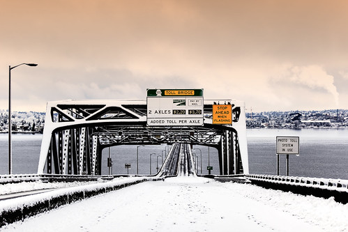
This was a scene from a wintry January SR 520 weekend closure as we continued work in the area to get ready for a new bridge. Although tolling on SR 520 officially started in 2011, 2012 saw drivers adjusting their commutes as they help pay for a safer, more reliable bridge.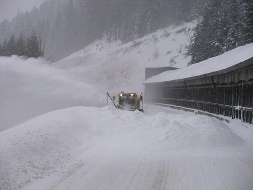
Early January saw significant snowfall to the mountain passes. Here we see a familiar scene on I-90 as crews perform avalanche control near the snowshed.
Not often do you see plows out in force on I-5 in Thurston County, but we saw that during storms in early January.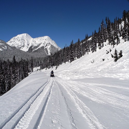
Crews checking out snow depth and conditions on the North Cascades Highway on March 7, 2012.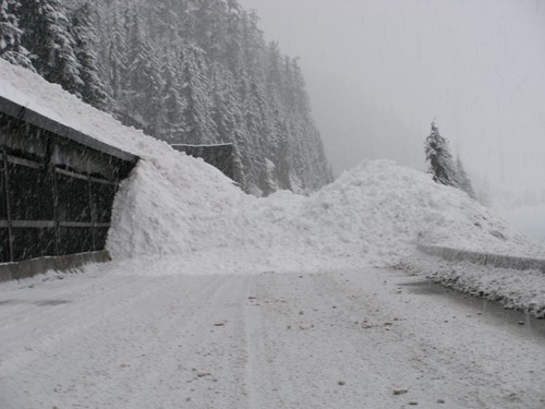
Snow continued to fall on the passes into March. Here we see a result of avalanche control on I-90.
SR 99 tunnel prep in Seattle continued throughout 2012.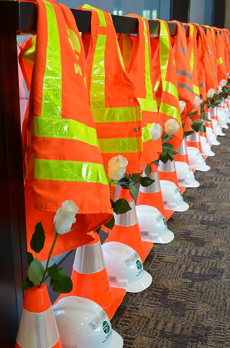
We take the time each year to remember those workers who lost their lives in work zones. There were some close calls but fortunately didn't lose anyone in 2012 and we're hoping you Give 'Em a Brake in 2013.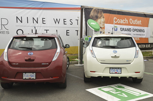
May 30, 2012, saw the grand opening of the West Coast Electric Highway, helping reduce range anxiety for electric vehicle drivers on main corridors in Oregon and Washington.
One of my personal favorites, banding a baby Peregrine Falcon. This chick is nesting in a box under the I-5 Ship Canal Bridge in Seattle. The mother of this chick has been on the bridge since 2002. Follow the entire account of falcon banding on our Storify site.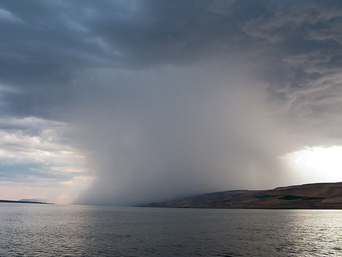
Anyone else remember that crazy storm we had in July? This particular cloud dumped several inches of rain on SR 14 and caused quite a mess with multiple mudslides and guardrail damage.
Automating the I-5 express lanes was a big step forward for us in 2012. Instead of taking an hour to change the lane direction, new equipment was installed that cut the time to 15 minutes. Watch a YouTube video describing these changes.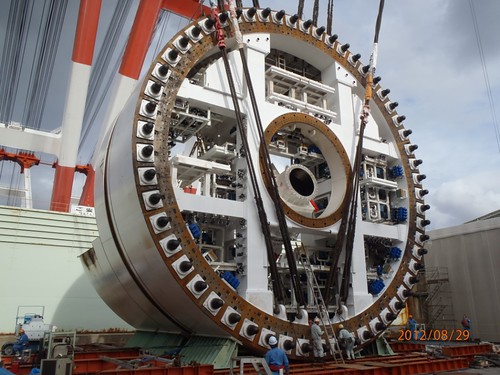
In August, we got our first glimpse of the world's largest-diameter tunnel boring machine. It was built in Japan and will dig the SR 99 tunnel beneath downtown Seattle starting in summer 2013.

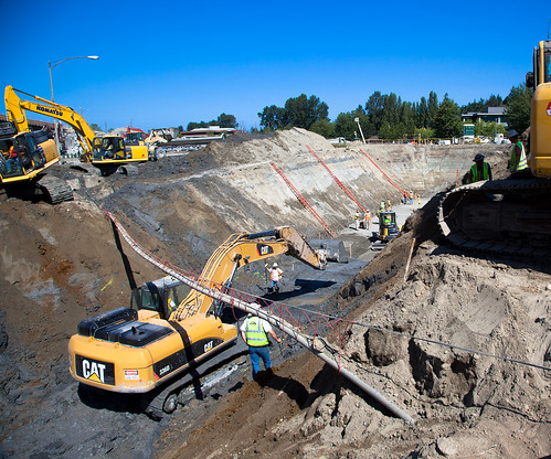
August saw more SR 520 weekend closures as construction continued throughout the year as we demolished overpasses, installed larger culverts and prepped the roadway for a new, wider SR 520.


2012 also saw construction of the first of two new Olympic Class, 144-car ferries. This one was named Tokitae.

 |

Sometimes you just can't give enough credit to crews out in the field who work to keep highways open. On a quiet Friday morning in October, 42,000 pounds of fish heads and guts were scattered across US 101 in southern Pacific County. The semi was off the road within a couple of hours, but it took many more to clean up all the residual. Yuck.
 |
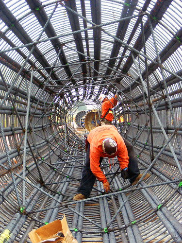
An artful shot of crews assembling rebar cages for the new I-5 Salmon Creek interchange, which is in it's final stages of completion.

We are gaining momentum in delivering nearly $800 million in federally funded rail projects with the goal of providing faster, more frequent Amtrak Cascades service between Seattle and Portland. Five of our 20 federally-funded projects were under construction or completed in 2012, with five more set to break ground in 2013. The most recent completed project added two new tracks through BNSF’s busy rail yard near Everett to reduce the conflicts and delays from freight traffic.

While this shot is of Mount Baker highway, which saw hundreds of trees down across the roadway, December saw a 69-hour closure of US 2 from Stevens summit to Leavenworth due to falling trees (first time for that…). It started on Saturday, Dec. 22, and continued through Christmas Day. This unique phenomenon even had prominent meteorologist Cliff Mass blogging about the falling trees.
For Stevens pass, despite the higher than usual snow totals for the past two La Nina winters, December 2012 beat them. We had a total of 253 inches by Dec. 22 – a total we didn't reach last winter until Jan. 23.

The launch pit for the SR 99 tunneling machine. When complete, it will be 400 feet long, 80 feet wide and 80 feet deep.
Social Media
Our social media audience continued to grow in 2012 as many people found value in the real-time information we provide via those channels. Here's an example of the content we put on Twitter.
In September, Apple released iOS 6 update that included their new mapping software. Realizing how dependent some folks are on their mobile devices for navigation we decided to raise awareness of the flaws in the new mapping system by using a little tongue-in-cheek humor on Twitter:
Although #ios6 may say differently, we can assure you that the Tacoma Narrows Bridges have not melted: bit.ly/NF6ccQ
— Washington State DOT (@wsdot) September 20, 2012

Here's a list of the rest of the best tweets of 2012.
Other notable items worth mentioning:
- First 520 pontoons floated into Lake Washington.
- For the first time, the Coast Guard began allowing boats to pass through the drawspan in the middle of the day with two hours notice. We had to figure out how to let drivers know before they were on the road that the bridge would open at a particular time. Our traditional alerts are primarily for media outlets. For this, we knew we had to reach drivers directly and do it in a way that gave them ample warning without overdoing it… as a result, a special alert just for 520 users that they could opt to receive as a text or an email.
- In May, crews completed an interchange on US 12 near Burbank, east of the Tri-Cities. The 60-mph traffic on US 12 no longer has to stop at a traffic signal, and SR 124 drivers now use freeway ramps to enter and exit US 12, reducing conflicts and collisions.
- Central Washington saw one of the worst forest fires in decades dubbed the Taylor Bridge Fire that closed SR 10 and US 97 multiple times in August.
- Two I-5 widening projects were under way last year, one in Clark County and one in Lewis County. Together, they total $288 million in gas tax investments and improve traffic flow for more than 100,000 drivers. Both are still under construction and scheduled for completion within the next two years.
- Two Clark County projects eliminated three at-grade intersections, one of which (SR 500/St. Johns) was one of the most dangerous in the area, with an average of one collision a week.
- Finally started construction on the new vessel for the Keller Ferry route. The “Sanpoil” will replace the “Martha S.’ which is the oldest vessel in our fleet, having been launched in 1948.
- Fully completed the north 5.7 miles of the 10.5-mile North Spokane Corridor freeway.
Quite a busy year when you look back on it, thanks for being there with us, here's to a safe 2013.
West Seattle Bridge interchange: Construction closures this weekend
Posted by Unknown in Columbian Way, construction, construction closures, I-5, SODO, viaduct, West Seattle Bridge on Wednesday, January 2, 2013
By guest blogger Jamie Holter
 |
| Crews will replace expansion joints on the I-5 ramps that connect West Seattle, Columbian Way and Spokane Street. |
This weekend, the first weekend in January, marks the official start of WSDOT’s 2013 Seattle area construction season. Construction crews will close the southbound I-5 ramp to the West Seattle Bridge and the westbound Columbian Way ramp to the West Seattle Bridge.
Traffic will be busier than usual as drivers wind their way to the West Seattle Bridge using the Viaduct, South Lander Street, Forest Street, First Avenue South and Fourth Avenue South.
During this weekend closure and the next 10 weekend closures, crews will replace 50-year old expansion joints, pieces of steel that run across all lanes and allow the bridge to bend and flex with heavy traffic and the freeze-thaw cycle.
Each weekend closure will be a different ramp. Drivers who want to take the guess work out of construction closures can check the color-coded map (pdf 515 kb). Engineers have planned out each weekend closure between now and April.
Don’t be surprised by construction. Know before you go in SODO.
State Route 99 – Two years in the transformation of Seattle’s first freeway
Posted by Unknown in Alaskan Way Viaduct, Demolition, Seattle, SR 99, viaduct on Friday, September 21, 2012
By guest blogger Greg Phipps
In summer 2010 contractor crews working for WSDOT started work to replace the aging Alaskan Way Viaduct south of Downtown Seattle. Two years later the seismically vulnerable viaduct is gone and drivers are traveling on a brand new, seismically-strong State Route 99 from SODO to Pioneer Square. This section of SR 99 won’t be truly complete until it connects to the SR 99 tunnel at the end of 2015. Still, it’s pretty cool to see how replacing the southern mile of the viaduct has changed the landscape south of downtown.
The southern mile
Our first photo shows the southern mile of the viaduct in May 2010, before crews started building the new SR 99. Besides the viaduct, keep an eye on a couple things that will change. The first thing is Alaskan Way South, the street on the west side of the viaduct. The second thing is the railroad tracks between the viaduct and Alaskan Way South.
The southern mile in September 2011
One year ago crews were close to finishing the western half of the new SR 99, the piece that would eventually become the southbound lanes of the highway. What happened to Alaskan Way South? Part of it is in the footprint of the new SR 99 bridge, while the rest has become a construction zone. And the railroad tracks? They’ve moved west, out of the way of the new highway.

Southern mile demolition – October 2011
Just one month later and the viaduct is a shell of its former self, literally. Demolition machines are hammering and crunching the double-deck viaduct into piles of concrete and rebar rubble. In a little more than a week most of the southern mile has disappeared. Meanwhile, crews are getting ready to open the western half of the new highway and the construction bypass that takes traffic from the new highway up to the remaining section of the viaduct north of South King Street.

The new Highway 99 - September 2012
It’s 11 months after the southern mile demolition and we’ve got twins! Bridges, that is. Southbound traffic rides on the west bridge and northbound traffic uses the east bridge, until they meet again and travel on a construction bypass around SR 99 tunnel construction. On the photo trace a line from the end of the east bridge through the tunnel construction zone toward the blue cranes on the bottom right. That’s your route into the tunnel starting at the end of 2015.

Replacing the Alaskan Way Viaduct: We’re ready. Are you?
Posted by Unknown in viaduct on Tuesday, August 31, 2010
For many years, the main questions surrounding the Alaskan Way Viaduct replacement were – what will be built and when will construction start? We began answering these questions earlier this summer, as crews broke ground on a project to replace the southern mile of the aging structure with a new side-by-side roadway. Now that construction has begun, the question becomes – how will people get around during this work? Luckily for those who depend on the viaduct and State Route 99 today, we’ve been planning this work for a long time. And the pieces to help keep things moving are falling into place.
In February 2008, we, along with the King County and the City of Seattle announced a package of transit service and capital investments to minimize travel delays and disruptions during construction to replace the viaduct’s south end. Our contribution totaled approximately $125 million. During the last two and a half years, we worked with our partners to add these improvements and bolster a system that already includes new Link light rail, upcoming RapidRide bus routes, West Seattle ferry service and repaved downtown streets.
We are doing everything we can to keep lanes open on SR 99 during the viaduct replacement. Through the south end construction area, at least two lanes will remain open in each direction at most times, but reduced speeds in this area mean people will need options for getting around. So, what improvements did we put in place, and how will they help you? Let’s look at the list:
 |
| SR 519 Project |
- This spring we completed the SR 519 project, which included a new I-5/I-90 westbound off-ramp to S. Atlantic Street/ Edgar Martinez Drive S. Drivers now have a new connection that provides better access from I-5 and I-90 to the waterfront.
- Earlier this year, King County Metro, with funding from us, added 31 new bus trips on four routes to and from southwest Seattle. Strategies to encourage the use of transit, teleworking and ridesharing will kick into high gear next year. To see how transit can help your commute to downtown, check out Metro’s Trip Planner.
- We also provided funding so Metro could expand its bus monitoring system. Completed this summer, the expanded system will help Metro monitor when travel times along transit routes are affected by construction, so they know when and where additional service is needed to help you reach your destination.
- This month we activated new overhead electronic signs on northbound I-5 between Boeing Access Road and I-90 that alert drivers to reduce speeds or change lanes when there are backups on the road ahead. We’ve also added new travel time signs on I-5. These tools provide real-time information to help drivers make their commute more manageable.
- The City of Seattle has opened its new Spokane Street Viaduct off-ramp to Fourth Avenue S. The eastbound off-ramp provides a new route into downtown for West Seattle commuters. Our contribution of $50 million completed full funding of the City’s $168 million Spokane Street project, allowing it to move into construction.
- We funded City projects to add and upgrade traffic signals and add new driver information signs in the Elliott Avenue/15th Avenue NW, West Seattle and south of downtown corridors. These improvements will help keep buses and traffic moving.
- Later this year crews will finish installing and testing new electronic message signs on SR 99 and other major routes leading to downtown. The signs will provide real-time information to drivers so they can choose less congested routes.
 |
| Smart Highway signs |
And if you have questions, we’re just an e-mail or a phone call away. You can reach us at viaduct@wsdot.wa.gov and 1-888-AWV-LINE (298-5463).
Walking tour will highlight past, future of Alaskan Way Viaduct
Posted by Unknown in history, viaduct, walking tour on Friday, August 20, 2010
By Ron Paananen, P.E., Alaskan Way Viaduct and Seawall Replacement Program Administrator
It’s easy to miss driving by at 40 miles per hour, but there it stands, at the north end of the Alaskan Way Viaduct, a red-brick reminder that it doesn’t pay to cut corners.
In fact, engineers building the viaduct in the 1950s found that cutting corners can be pretty expensive – about $50,000, actually.

Back in the 1950s, as the viaduct began to take shape along the downtown Seattle waterfront, engineers discovered a problem: the corner of Belltown’s Empire Laundry Building stood directly in the structure’s path. Rather than shave off the building’s corner – which would have cost the hefty sum of $50,000 – engineers improvised by incorporating the building into the guardrail. The results are still visible today to the south of the Battery Street Tunnel, with the corner of the building – now home to condominiums – protruding through the rail.
It’s one of the few times you’ll see a building in the right of way, and one of many tidbits from the viaduct’s past that we’ll be exploring at a historical walking tour on Saturday, Aug. 21. I’ll be leading the tour, along with historical preservationist Mimi Sheridan and other viaduct experts.
We’ll depart from the Washington Street Boat Landing (Alaskan Way S. and S. Washington Street) at 10 a.m. Over the course of two hours, my colleagues and I will dust off stories from the viaduct’s past – like that of the Empire Laundry Building – to bring to life the people and places that helped define the structure and the downtown waterfront. We’ll make stops at various points of interest along the waterfront before wrapping up near the Pike Street Hillclimb. Topics include the changing transportation needs of Seattle, the important role of the viaduct in the growth of downtown, and our plans to replace the vulnerable structure.
The event is part of the Museum of History and Industry’s (MOHAI) “Summer History Tours” series. Tickets are $15 for MOHAI members or $20 for the general public, and can be purchased in advance at www.brownpapertickets.org or by calling 1-800-838-3006. Tickets will also be available for purchase at the beginning of the tour, provided it doesn’t sell out in advance. The neighborhood is well served by transit, and parking is available nearby under the viaduct.
This will be a fun way to take a look back, but it’s worth noting that we’ve come a long way since the 1950s. As we begin replacing the viaduct, we’re taking every precaution to protect the public’s investment and make sure we build something that people will be proud of 50 years from now.
Which means no improvising. And, of course, no cutting corners.
Earthquake simulation highlights the vulnerabilities of the Alaskan Way Viaduct
By guest blogger Ron Paananen
The double-deck Alaskan Way Viaduct, a fixture on Seattle’s downtown waterfront for more than five decades, was already showing signs of wear and tear when the last major earthquake struck in 2001. That 6.8 magnitude seismic event further weakened the structure by damaging its joints and columns and causing sections to settle into the loose fill soil in which it was built.
In the years since, crews have kept a close eye on the viaduct through quarterly inspections and have strengthened several columns to prevent further damage to the structure, but the threat of another earthquake was always present. During this time new soil data and a better understanding of local and regional seismic behavior clarified exactly how vulnerable the viaduct is to another earthquake. In 2007 we released a report that concluded there is a higher chance – specifically, a one in 10 chance in the next 10 years – of an earthquake occurring that could cause portions of the viaduct and adjacent seawall to collapse. The vulnerability analysis is available on our Web site.
A simulation based on the 2007 report demonstrates how disastrous a strong earthquake could be for the Alaskan Way Viaduct. It shows what could happen if a seismic event more intense than the 2001 earthquake were to shake the Puget Sound region again. To say that the damage to the viaduct and the seawall would be severe would be an understatement.
We understand the risk, and we are making progress to replace this vulnerable structure. Early next year we will begin major construction to replace the southern mile of the viaduct, and the state, King County and the City of Seattle have agreed to a plan to replace the section along the waterfront (The plan, calling for a bored tunnel beneath downtown, is currently under environmental review.) State and city crews also continue to monitor the structure and ensure it remains safe for drivers.
We are also installing an automated closure system next year that will keep drivers from using the viaduct after an earthquake, fire, or other event compromises the structure. The new system will use the latest in monitoring technology, including GPS antennas and wireless equipment, to detect structure and ground movement. New signs and gates at the viaduct’s ramps and entrances will detour traffic away from the structure during an emergency, and advance warning signs will notify drivers in SODO, West Seattle, downtown and north of Seattle about any closures.
The specter of another major earthquake, however, is always present. That is why we are determined to replace the Alaskan Way Viaduct before Mother Nature makes the decision for us.
You can watch the video on our streaming server if you can't access it on YouTube.

 |
 |
 |
 |
 |
 |
 |
 |
 |
 |
 |
 |
 |
 |
 |


