Showing posts with label North Cascades Highway. Show all posts
Pass clearing continues on North Cascades Highway
Posted by Unknown in North Cascades Highway, North Cascades pass snow, north cascades pass snow removal, SR 20 on Tuesday, April 15, 2014
By Jeff Adamson
They’re back…Pink Floyd and his family of avalanche safety flamingos. Yes, they ARE cute, but they have an important duty.
 |
| Pink Floyd pointing out work zone hazards. |
The flamingos are eye-catching tools that point out hazardous zones to the snow removal teams. They’re reminders to always have your “avalanche eyes” open for chutes, debris, another work crew and other hazards. Now if we could only agree on which song to go with our mascot...
East side update
On Monday, April 7, Pink Floyd joined the east side snow removal effort on SR 20 – North Cascades Highway as the team’s avalanche training refresher at Silver Star Gate kicked off the second week of this massive snow removal project . Then it was off to begin clearing just above Lone Fir Campground.
While the maintenance crew pushed and blew snow from SR 20, the avalanche team climbed to the 6,200-foot-level up Liberty Bell Mountain.
 |
| Snow blower at Lone Fir Campground. |
Spring’s rising temperatures can trigger snow slides below – a major hazard for crews. The avalanche control team dug a snow pit and assessed the Liberty Bell Mountain zone to determine which layers of snow might separate and slide. It tells them what the avalanche potential is and what kind of snow movement to look for when the maintenance crew progresses into the giant Liberty Bell avalanche zone.
In years past, the avalanche control team doesn't join the clearing effort until the east side maintenance crew reaches Cutthroat Ridge in the second or third week. The zone has 12 active chutes. This year, the avalanche team has been on site monitoring unstable slopes since week one. Most of the winter’s snowfall didn't start falling until mid-February so what’s on the slopes isn't as stable as snow that’s spent all winter compacting on itself.
 |
| A second bulldozer joined the east side clearing effort. |
The solution is to cut the top layer off (anything over 6 or 8 feet) and the tool of choice is a bulldozer or two. Through the Cutthroat zone, a D-6 caterpillar worked the top of the slide and when its work was done, the maintenance crew’s excavator, snow blower and a grader cleared the snow down to the pavement.
When they get to the end of the Cutthroat zone, a larger D-8 cat we lease from a local logging company joins the effort to cut down the top layer of the more than 30-foot-deep slides in the Liberty Bell Mountain zone.
West side update
Eastbound SR 20 clearing continued on Monday, April 7, just beyond the Canyon Creek Trail.
 |
| Snow blower on SR 20 just below Easy Pass. |
By the end of week two, the two-man team had eastbound lanes cleared and widened to about three miles short of Swamp Creek. The less-than-a-foot snow depth increased to 4 feet as they worked towards Rainy Pass. Next, the team will be moving forward towards Easy Pass.
Here are some short answers to questions you might have:
- The closure gates stay closed until the entire highway is reopened (estimated about the second week in May)
- No licensed motor vehicles are allowed beyond the gates, but boots, bikes and snow mobiles are.
- We work Monday through Thursday, leaving Friday through Sunday for uncontested(!) recreation, but we encourage you to check the back country avalanche forecasts and weather before you go
- We also ask you to stay clear of our clearing equipment so no one gets hurt or hurts it
SR 20 - North Cascades Highway snow removal is underway
Posted by Unknown in North Cascades Highway, North Cascades pass snow, north cascades pass snow removal, SR 20, Washington Pass on Wednesday, April 2, 2014
Clearing work began this week to open State Route 20 - North Cascades Highway.
 |
| Snow blower clearing nearly a foot of snow from the west side of SR 20 at Diablo Gate. |
East side progress
Maintenance techs from Twisp set off Monday, March 31, to start blowing and pushing snow from the closure barricades at the Early Winters Information Center up to the Silver Star Gate. That’s a seven-mile stretch on the east side of SR 20.
Crews had cleared two snow blower widths of snow from between those mileposts by Tuesday evening. Clearing work begins today on the shoulders and pullouts throughout that area in addition to the parking and turnaround space at the Silver Star Gate.
In years past, maintenance techs start the clearing process on either side of the pass. An avalanche control team member joins the process once the crew reaches the Cutthroat Ridge avalanche zone to watch for avalanche activity. That person is essentially a spotter for those clearing the highway.
This year is different.
Crews discovered during their assessment last month that Delancey Ridge avalanche zone had come in with snow and debris reaching the road – a first in recent memory for our clearing team.
With that much snow, maintenance crews need their spotter early. They’ll be joined by a member of the avalanche crew on Monday, April 7.
West side progress
Work on the west side began Tuesday, April 1, once maintenance technician Bob Hopfield took control of his usual spring “ride” – a loader-mounted snow blower – at Diablo Gate.
 |
| An in-progress view of the Rudy Ridge snow slide clearing process. |
The snow depth at Diablo Gate has melted down to less than a foot deep. Further up the highway, the snow is nearly two-feet-deep. The Ruby Ridge avalanche zone has been active as well, with chute #10 covering both lanes of SR 20 with a dozen feet of snow. This is a relatively small slide.
By the end of Tuesday, the crew had cleared a single lane all the way to milepost 144, just before East Creek Trail. Next up is widening the cleared area and tackling the clean-up of the Ruby Ridge avalanche zone slide.
 |
| A bank of snow on the shoulder of SR 20 at the Ruby Ridge slide. |
Late snow meant a late start to snowmobile season this year. The west side clearing team is leaving snow on the westbound SR 20 lanes from the gate to Granite Creek for up to two extra weeks to give snowmobilers more time on the snow. The beginning of westbound lane clearing and ditching work will mark the end of snowmobile season from the west.
In the meantime, crews are clearing and widening only the eastbound lanes for the 14 miles up to Granite Creek.
For the latest SR 20 – North Cascades Highway news, visit our website or sign up for email updates. See even more SR 20 clearing photos on Flickr.
2012 In Pictures
Posted by Unknown in 2012, electric cars, North Cascades Highway, NSC, photos, SR 520, viaduct, year in review on Tuesday, January 8, 2013
I continue to be fascinated how transportation affects each and every one of our lives. Whether it be a trip to the grocery store, a commute to work or a vacation trip across the state, we rely on this system to help us get to our destinations. I thought it would be worth reflecting on 2012, and hope you enjoy the journey with me.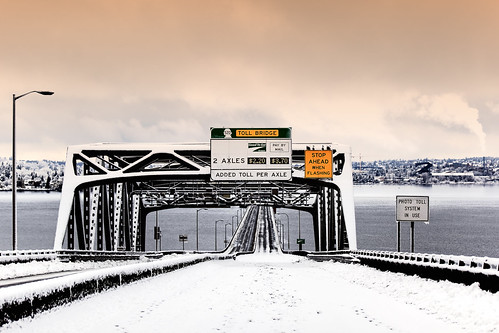
This was a scene from a wintry January SR 520 weekend closure as we continued work in the area to get ready for a new bridge. Although tolling on SR 520 officially started in 2011, 2012 saw drivers adjusting their commutes as they help pay for a safer, more reliable bridge.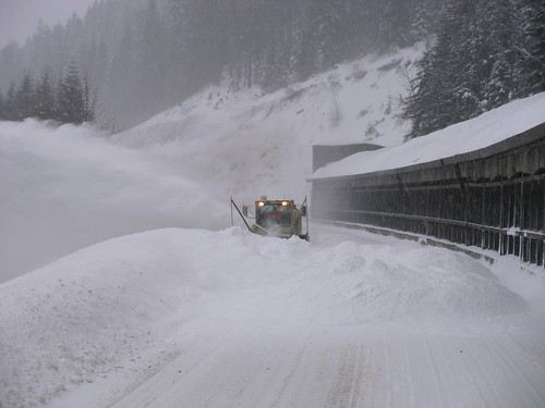
Early January saw significant snowfall to the mountain passes. Here we see a familiar scene on I-90 as crews perform avalanche control near the snowshed.
Not often do you see plows out in force on I-5 in Thurston County, but we saw that during storms in early January.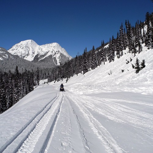
Crews checking out snow depth and conditions on the North Cascades Highway on March 7, 2012.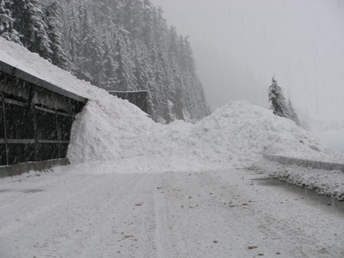
Snow continued to fall on the passes into March. Here we see a result of avalanche control on I-90.
SR 99 tunnel prep in Seattle continued throughout 2012.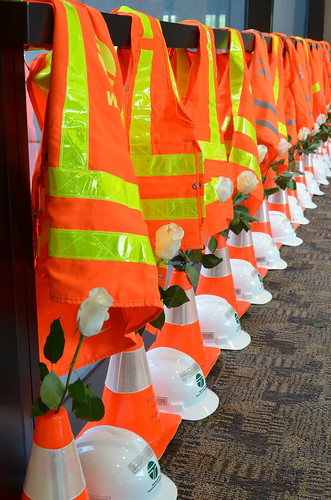
We take the time each year to remember those workers who lost their lives in work zones. There were some close calls but fortunately didn't lose anyone in 2012 and we're hoping you Give 'Em a Brake in 2013.
May 30, 2012, saw the grand opening of the West Coast Electric Highway, helping reduce range anxiety for electric vehicle drivers on main corridors in Oregon and Washington.
One of my personal favorites, banding a baby Peregrine Falcon. This chick is nesting in a box under the I-5 Ship Canal Bridge in Seattle. The mother of this chick has been on the bridge since 2002. Follow the entire account of falcon banding on our Storify site.
Anyone else remember that crazy storm we had in July? This particular cloud dumped several inches of rain on SR 14 and caused quite a mess with multiple mudslides and guardrail damage.
Automating the I-5 express lanes was a big step forward for us in 2012. Instead of taking an hour to change the lane direction, new equipment was installed that cut the time to 15 minutes. Watch a YouTube video describing these changes.
In August, we got our first glimpse of the world's largest-diameter tunnel boring machine. It was built in Japan and will dig the SR 99 tunnel beneath downtown Seattle starting in summer 2013.

August saw more SR 520 weekend closures as construction continued throughout the year as we demolished overpasses, installed larger culverts and prepped the roadway for a new, wider SR 520.


2012 also saw construction of the first of two new Olympic Class, 144-car ferries. This one was named Tokitae.

 |

Sometimes you just can't give enough credit to crews out in the field who work to keep highways open. On a quiet Friday morning in October, 42,000 pounds of fish heads and guts were scattered across US 101 in southern Pacific County. The semi was off the road within a couple of hours, but it took many more to clean up all the residual. Yuck.
 |
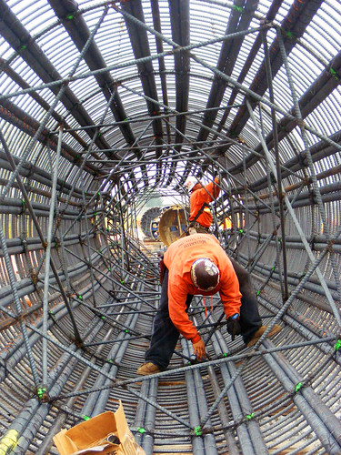
An artful shot of crews assembling rebar cages for the new I-5 Salmon Creek interchange, which is in it's final stages of completion.

We are gaining momentum in delivering nearly $800 million in federally funded rail projects with the goal of providing faster, more frequent Amtrak Cascades service between Seattle and Portland. Five of our 20 federally-funded projects were under construction or completed in 2012, with five more set to break ground in 2013. The most recent completed project added two new tracks through BNSF’s busy rail yard near Everett to reduce the conflicts and delays from freight traffic.

While this shot is of Mount Baker highway, which saw hundreds of trees down across the roadway, December saw a 69-hour closure of US 2 from Stevens summit to Leavenworth due to falling trees (first time for that…). It started on Saturday, Dec. 22, and continued through Christmas Day. This unique phenomenon even had prominent meteorologist Cliff Mass blogging about the falling trees.
For Stevens pass, despite the higher than usual snow totals for the past two La Nina winters, December 2012 beat them. We had a total of 253 inches by Dec. 22 – a total we didn't reach last winter until Jan. 23.

The launch pit for the SR 99 tunneling machine. When complete, it will be 400 feet long, 80 feet wide and 80 feet deep.
Social Media
Our social media audience continued to grow in 2012 as many people found value in the real-time information we provide via those channels. Here's an example of the content we put on Twitter.
In September, Apple released iOS 6 update that included their new mapping software. Realizing how dependent some folks are on their mobile devices for navigation we decided to raise awareness of the flaws in the new mapping system by using a little tongue-in-cheek humor on Twitter:
Although #ios6 may say differently, we can assure you that the Tacoma Narrows Bridges have not melted: bit.ly/NF6ccQ
— Washington State DOT (@wsdot) September 20, 2012

Here's a list of the rest of the best tweets of 2012.
Other notable items worth mentioning:
- First 520 pontoons floated into Lake Washington.
- For the first time, the Coast Guard began allowing boats to pass through the drawspan in the middle of the day with two hours notice. We had to figure out how to let drivers know before they were on the road that the bridge would open at a particular time. Our traditional alerts are primarily for media outlets. For this, we knew we had to reach drivers directly and do it in a way that gave them ample warning without overdoing it… as a result, a special alert just for 520 users that they could opt to receive as a text or an email.
- In May, crews completed an interchange on US 12 near Burbank, east of the Tri-Cities. The 60-mph traffic on US 12 no longer has to stop at a traffic signal, and SR 124 drivers now use freeway ramps to enter and exit US 12, reducing conflicts and collisions.
- Central Washington saw one of the worst forest fires in decades dubbed the Taylor Bridge Fire that closed SR 10 and US 97 multiple times in August.
- Two I-5 widening projects were under way last year, one in Clark County and one in Lewis County. Together, they total $288 million in gas tax investments and improve traffic flow for more than 100,000 drivers. Both are still under construction and scheduled for completion within the next two years.
- Two Clark County projects eliminated three at-grade intersections, one of which (SR 500/St. Johns) was one of the most dangerous in the area, with an average of one collision a week.
- Finally started construction on the new vessel for the Keller Ferry route. The “Sanpoil” will replace the “Martha S.’ which is the oldest vessel in our fleet, having been launched in 1948.
- Fully completed the north 5.7 miles of the 10.5-mile North Spokane Corridor freeway.
Quite a busy year when you look back on it, thanks for being there with us, here's to a safe 2013.
North Cascades Highway - getting snow in May!
Posted by Unknown in avalanche, North Cascades Highway on Monday, May 3, 2010
By guest blogger Jeff Adamson
Hi all,
You probably know the North Cascades is closed. It snowed all night and when Liberty Bell #3 filled and dumped across the road, the plow truck driver who had been working all night was told to get out of there, and close the gate on his way. The forecast says we've got another foot or more coming between now and tomorrow, so it's not safe for our crews to be working under unstable avalanche chutes anymore than it's safe for you to be driving under them. I'm rooting around through the record books and haven't yet found an avalanche closure this late - but I'll keep looking. I just got off the phone with Mike Stanford, our Avalanche Control Chief. He will be up there tomorrow doing the assessment of avalanche danger. He's taking the howitzer along so if some avalanche control blasting can get us open again quickly, he'll be able to do it. It really depends on what happens to the Cutthroat Ridge chutes - if they're full and unstable - we might just have to wait a day or two for the temperature increase that's coming later in the week to cause them to empty. (Due to the topography, you can't shoot Cutthroat starting zones from the highway with the 105mm.)
By the way - depending on how much of the forecast' 6 to 10 inches of snow hits Stevens - he may have to deal with some avalanche issues before he leaves his office at Berne Camp (that's our maintenance facility 8 miles east of Stevens Summit.)
Sorry, no pictures (no one better be up there to take any!) We're manning the gates just in case any back country recreationist we weren't able to contact show up wanting to go home.
Here's what the Highway Alert that went out this morning:
WSDOT Alert
DATE/TIME: May 3, 2010, 9:30 a.m.
DESCRIPTION: SR 20, the North Cascades Pass, is closed from milepost 134 to milepost 170.
LOCATION: SR 20 at milepost 170 North Cascades Pass
START: May 3, 2010, 9:30 a.m.
Est. END: Unknown
OTHER: Due to avalanche danger, high winds, and incoming snow, the North Cascades Pass is closed until further notice.
CONTACT: NCTMC (509) 667-2802
Here's the forecast:
Snow over Washington and Rainy passes will continue through the day today with heavy snow showers and squalls expected during the midday and afternoon hours. There is the potential for significant snow accumulations over both Washington and Rainy passes (upwards of 12”+), with slush potential as low down the hill as Diablo on Mon afternoon and evening. Most of the snow concerns remain over the passes, with little cold-moisture making it much further E than Early Winters. Snow levels may drop as low as 1,500 feet Monday night into Tuesday morning with more snow expected, mainly West of the passes.
Happy May!
(This was sent out via the North Cascades email distribution list this morning. Sign up to get this and much more information sent directly to your inbox. )
Thanks for the tradition Tootsie!
Posted by Unknown in cinnamon rolls, North Cascades Highway, wsdot on Tuesday, April 20, 2010
by guest blogger Jeff Adamson
Every year when the North Cascades highway opens in the spring, Tootsie is there to celebrate with the crews with warm cinnamon rolls. This year marks the third year in a row that she has had the honor of opening the gate.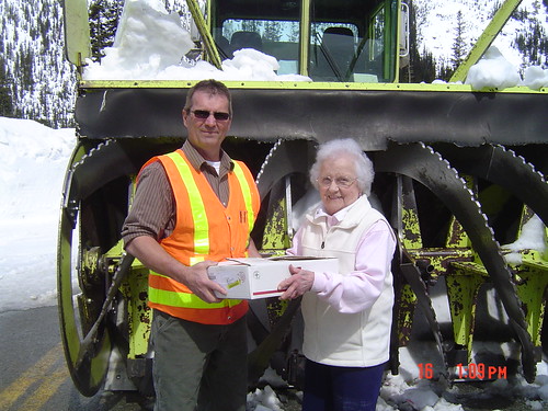
She can’t remember exactly how long she’s been taking cinnamon rolls up to the Diablo Gate. She says she and her husband did it a few times after it opened in ’72, but it wasn’t until “20 or 25 years ago that I started doing it regularly”, she said.
It began as a tribute to her dad who was a big supporter of the North Cascades Highway’s construction, but he died before it opened.
This year, despite stuffing the trunk of her Caddy, “I ran out of cinnamon rolls for the first time!” She’s not sure how many she started with – “between the coffee and the rolls, I usually get up there with about 60.” “This year, there were the most people I’ve ever seen waiting in line. We get there at 6 a.m. to be first in line and we had company!” She usually just brings her cinnamon rolls to those in line who are waiting, this is the first year that she drove up to Washington Pass to provide cinnamon rolls to the crew.
When asked if she was going to give it up after next year – her 90th – she said “Nope, I’m going to start back. I’m going to be 89 again!”
She typically starts baking at 1 a.m. “so the cinnamon rolls are still warm when we get to the gate.”
Thanks for the warm and delicious tradition Tootsie!
Why wait to assess the reopening for the North Cascades Highway until Feb. 22?
Posted by Unknown in avalanche, North Cascades Highway on Wednesday, February 17, 2010
by guest blogger Jeff Adamson
The question comes up every time we have a mild “El Nino” winter in the Cascades, but the answer is the same. Sending our Avalanche and Maintenance crews to do a reopening assessment any earlier than late February/early March, wouldn’t work since there's still too much winter ahead. They need to be able to make any objective determinations about when to begin the reopening process. That is, setting a firm start date, figuring out how much and what kind of equipment will be needed (for example, we have to put the caterpillar work out for competitive bids) and get our internal crews and equipment lined up. North Central Region has a 3 man avalanche control team, Avalanche personnel are required to be on site while the crews are clearing the highway through the avalanche zones. Last year, for example, work on the North Cascades was delayed a couple of times when the Avalanche team had to go back to Stevens Pass in order to keep it open. The Kodiak snow blowers we use are from the three assigned to Stevens pass and can’t be released to NCH until they're not needed there. That means the clearing work usually begins with only one blower and more are “sent north” as they’re “available”.
Our Avalanche forecasters have lots of historical data and "know snow" and have done a pretty good job over the years picking a start date that worked, but doing the assessment any earlier could be risky and really unnecessary.
While we're always being urged to open the highway as soon as possible (preferably by the opening weekend of fishing season), we also hear from some winter recreation businesses that ask us not to open before Easter because when we do, it costs them business! Apparently, we’ll never please everyone.
Please remember that on the North Cascades, we do not do “active” avalanche control like we do on Stevens and Snoqualmie. Washington (and also Chinook) pass are federally designated Scenic Highways that are closed during winter. We really can't knowingly put our crews or drivers at risk by opening a highway before it can really stay open. In 2005, we had the earliest SR 20 opening ever on March 10. By opening that early, and then having a huge storm hit, refilling avalanche chutes, closing the road again for 10 days, we had to bring back the crews, equipment, etc. and repeat much of the reopening work. That "extra" clearing effort might not be considered to have been the best use of our gas taxes.
By the way, checking that last "El Nino" year for Stevens Pass one finds we had almost no avalanche control and low snow accumulations until March when we got hammered with almost 200" of snow. By way of comparison - there's less than 90 inches on the ground now and the total accumulation for this season, so far, is less than 250 inches. Last year’s season total was about average at 434 inches.
Tracking the giant icicle
Posted by Unknown in icicles, North Cascades Highway, SR 20, winter weather on Tuesday, December 16, 2008
 As temperatures across the state plunge to what seem like arctic levels, maintenance crews are faced with some unique challenges in their quest to keep the roads drivable. On SR 20, just east of Newhalem, crews battle giant icicles. Seriously.
If you drive SR 20 during the summer, you may not think much of the water that seeps through the rock as you pass through the tunnels east of Newhalem. But in the winter, when the weather drops below freezing, that water can become a hazard for drivers. The icicles that form on the walls and ceiling can get so large that they nearly impede traffic. And the constant dripping of water onto the road creates several icy patches.
Our maintenance crews are up in the area several times a week during cold weather, making sure the icicles don’t grow too large and placing deicer and sand on the road to keep it safe for drivers.
|
|
|
|
|
|
|
|
|
|
|
|
|
|
|
|
|
|


