Showing posts with label wsdot. Show all posts
Got goats? We do and we’re using them to remove invasive weeds and save money!
Posted by Unknown in blackberry vines, goats, Heidi Holmstrom, invasive weeds, Japanese knotweed, knotweed, Maintenance, scotch broom, sweet pea, Vancouver, wsdot on Wednesday, October 15, 2014
By Tamara Hellman
In a creative approach to getting more done with less, Heidi Holmstrom, one of our maintenance technicians from our Vancouver office, came up with the idea of using her pet herd of goats to remove invasive weeds like the Japanese knotweed. Seeds from the knotweed plant are transferred by water and sediment; quickly becoming a big problem in Clark County.
 |
| Front row: Choco, Buttons, Fergie and Taffy. Second row: Daisy and Irma. Third row: Mocha, Latte, Cappuccino and Breve. |
Heidi’s herd of 15 goats resided in an acre and a half of land this summer off State Route 503 near Brush Prairie. The area was fenced to make sure the goats did not take off or block the roadway. During the summer the group of goats chomped away at the invasive Japanese knotweed; but also other weeds like sweet pea, blackberry vines and scotch broom. Not only do the goats get a decent meal out of the deal, their two-stage digestion process ensures the invasive plants do not re-root and continue to spread.
 |
| Maintenance Tech Heidi Holmstrom with a baby goat. |
Another benefit of going goat is we avoid costly herbicide on the knotweed. The most effective application, aside from using goats, is injecting herbicide directly into the root of each plant. That process takes time, equipment and staff hours away from other roadway maintenance work. Cutting down the Japanese knotweed isn’t a good option as it becomes a bigger problem, because segments will re-root themselves, becoming brand new plants that just keep multiplying.
 |
| Irma is ready for her close-up. |
The goats are on winter break, but will be back to work in the spring and hungry for more.
#I90to1 by the numbers
Posted by Unknown in Bellevue, construction, expansion joint replacement, I-90, Issaquah, Mercer Island, traffic and travel, westbound I-90 closure, wsdot on Wednesday, July 23, 2014
By Afternoon Traffic Gal, aka Harmony Haveman Weinberg
Three weekdays down and just one more to go as we each continue to do our part by adjusting our driving/biking/riding/busing habits during the westbound I-90 lane closures to replace two worn out expansion joints.
WSDOT engineers released the latest traffic volumes on I-90 that show just how the commute looked each day this week so far and compared it to averages taken earlier this month.
Check out the graph below and follow the RED line for Monday, the GREEN line for Tuesday and the PURPLE line for Wednesday up until noon. The BLUE line shows the typical average times and volumes when all lanes are open on westbound I-90. As you read the graph you can see drivers who took westbound I-90 through the construction zone have consistently left earlier each day this week than they usually do. Many drivers found alternate routes or changed up their travel plans all together to avoid getting caught in a major backup.

This graph shows travel time comparisons for the first three commutes of #I90to1 against last week's westbound I-90 commute, which is in grey. With this we can tell that drivers are adjusting their trips with the peaks periods beginning earlier in the day. This helps keep traffic moving through the work zone.

We credit all commuters for helping with #I90to1! Let’s keep it up! We are almost finished!
~ Afternoon Traffic Gal
US 12 over White Pass to reopen this weekend
Posted by Unknown in emergency operations, Governor Inslee, US 12, White Pass, wsdot on Thursday, October 3, 2013
by guest blogger Meagan McFadden

 |
| Aerial view of the slide |
Governor Inslee signed an emergency proclamation on Thursday, Oct. 3 which give us and local agencies the green light to pursue federal emergency relief funds for the fix.
We already have an emergency contractor on board, DBM Inc., of Federal Way, who is working with us to develop a temporary fix so we can get this section back open to two before winter.

Currently, US 12 remains closed to from just west of Naches at milepost 183, to just east of Packwood at milepost 138. Truckers and other commercial vehicles are not allowed past these closure points. Locals going west can get to recreational areas and businesses along US 12 up to the west end near of Rimrock Lake and those going east can get up to the summit of White Pass.
Seattle is a happening town...
Posted by Unknown in Alaskan Way Viaduct, Comicon, construction closures, seattle traffic, Sounders. CenturyLink field, wsdot on Wednesday, February 27, 2013
The Puck Test
Posted by Unknown in pavement, technology, traffic, wsdot on Friday, January 25, 2013
by Guest blogger Mike Allende
Hockey is a winter sport and WSDOT is getting in on the puck action. Well, kind of. While it doesn’t involve goalies, slap shots or penalty boxes, this action may end up helping traffic move more efficiently.

Soon we’ll be giving Sensys Puck road sensors their first Seattle-area tryout when we install them on northbound I-5 near Northgate. It’s a test project pitting the youthful technology of these wireless sensors against the veteran savvy of existing loop detectors embedded in the roadway in a heated matchup to see which performs best in gathering traffic and vehicle information.

Loop detectors only work with good pavement, and funding for pavement preservation is looking grim. We still need to have reliable traffic information, so as an alternative, the plucky pucks may be the answer.
The pucks are compact and solid, just 3 inches tall and 3 inches in diameter, but don’t let their size fool you. There’s plenty of power and versatility packed in those little bodies and they hold up well under pressure, whether it’s a semi-truck or heavy rain.
What can these little guys do? Plenty. They count every car as it goes by, measuring speed, lane occupancy, gaps between vehicles, direction of travel and even vehicle length. This information is valuable in evaluating traffic flow and signal control, and letting drivers know if a road is congested or not on our flow map. That’s some MVP ability.
Inductive loops have similar skills but require pavement that is in good shape in order to work well. Pucks are also easier to handle than the gangly and awkward loops. That means they can get in position quicker, usually just 10 to 15 minutes per puck, leading to a much shorter disruption of traffic. Two loops, on the other hand, take about two hours to install.

To prepare for the puck’s debut, crews bore a circular hole in the pavement, about 4 inches wide and 4 inches deep. We want to put the puck in the best position to be successful, so crews level the holes so that each sensor gets an accurate reading.

After the pucks are in position, they're well protected with a strong epoxy. These guys are valuable and they need to be taken care of. They look sharp and impressive in their black uniforms, but at the same time aren't distracting. They'll fit right in.

The pucks aren’t going to be on their own, though. They team with a local controller, which receives transmissions and crunches data from each individual sensor. The controller can give an overall report about the presence of vehicles, average number of vehicles at any time, average speeds and lane occupancy, among other information. That’s some great teamwork! Loops also work in tandem but have to be hard-wired to a controller device, meaning there are only particular areas they can work without incurring a huge cost.
The pucks often make their appearance overnight to little fanfare, and can even be installed using a brief traffic slowdown rather than lane closures, unlike the loop sensors. They are run by battery and expect to have a long 10-year career. They’re also healthy, and unless the battery dies or there’s an epoxy failure, there shouldn’t be any other maintenance necessary. If maintenance is needed, the pucks can easily be popped out of the pavement, minimizing concrete damage. The health of loops is more questionable, as maintenance is a big issue with these guys. Some loops hold up well over time, others have to retire after 2 or 3 years. Maintenance involves digging up the concrete, dealing with the loop, and replacing the concrete, a much more invasive process. These are huge factors as pavement preservation is vital with increasing traffic. The less the ground has to be dug up, the longer it will last.
So who’s it going to be, the grizzled veteran or the intriguing rookie? The Northgate project costs about $20,000 while a comparable setup with the loops would be about $15,000. The signing bonus is higher for the pucks but add in the costs of maintenance down the road and the potential traffic disruptions and the up-front cost may be worth it. Clearly there are pluses and minuses with both, so the result of this tryout is going to be interesting and exciting to watch!
Putting it back together again
Posted by Unknown in bridge repair, Everett, Marysville, sr 529, wsdot on Thursday, December 6, 2012
When a vital roadway gets knocked out of service, it's our job to get it back open as quickly as possible for drivers, and emergency responders. Fixing something like a bridge fixed is by no means, a small feat. An average of 15,000 vehicles each day use the northbound lanes of the SR 529 Snohomish River bridge from Everett to Marysville. This hard-working blue-collar bridge has been around for 85 years and took quite a beating this weekend when a driver smacked an SUV into a couple of support beams.

For safety, our inspectors closed the northbound bridge until the damaged support beams could be fixed. These are critical pieces that support the bridge deck. Replacement parts can't be ordered out of a catalogue, we had to custom make them from raw steel.

A team of about 30 worked in shifts around the clock to design, fabricate and install a new diagonal and vertical support beam.


After about 500 combined hours of work, the northbound SR 529 Snohomish River bridge reopened to traffic at about 12:30 p.m., Tuesday, Dec. 4. We don't roll the dice on safety. It's pretty amazing how quickly it all came together. In 81 hours, the bridge went from damaged to repaired. We closed it, stabilized it, designed replacement parts, fabricating and installed them - and only disrupting one event commute for drivers.
WSDOT helps to get the lights back on
Posted by Unknown in partnerships, puget sound snow, winter, wsdot on Tuesday, January 24, 2012

To make sure the lights and heat come back on as quickly as possible, our Olympia-area maintenance road crews are out with utility crews, working traffic control for Puget Sound Energy and others repairing downed power lines.
 Monday, the crews were working on the tree-lined back roads of south Thurston County between Olympia and Centralia. These were hard hit with snow and ice last week and when branches fell, they took with them power lines on roads like State Route 121 near Millersylvania State Park and SR 507 between Tenino and Centralia, plus many city and county roads.
So what does a flagger or pilot car have to do with getting the lights on? Holding that stop/slow sign or leading traffic through the same 1/4-mile route over and over may not seem to help get power back on, but it’s those vital tasks that allow utility crews up in that bucket truck get their job done faster and safer, and make sure drivers get around those crews and back home.
 Where, hopefully, the heat will be on soon.
 Recycling bridges the gap between cost and environment
Posted by Unknown in aurora bridge, Bellevue, Demolition, I-405, Recycling, Sustainable Transportation, wsdot on Thursday, April 28, 2011
By guest blogger Noel Brady
You recycle those paper cups, bottles and old documents to keep them out of the landfill. Curious to find out how much landfill space a 300-foot-long, four-lane bridge would take?
Neither was our I-405 project team. That’s why we recycled 100 percent of the NE 12th Street bridge in downtown Bellevue after crews demolished it in March to make way for a longer, wider bridge to connect new ramps to I-405 and SR 520.
After bringing down the bridge, crews hauled away nearly 4,000 tons of concrete, 225 tons of rebar and truck loads of wood to recyclers. In addition to cutting carbon emissions from production, recycling construction materials saves money. 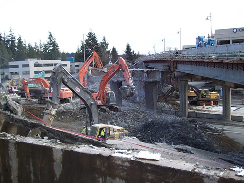
“In the old days it would’ve been taken to a landfill”, said Seema Javeri, WSDOT Project engineer. “Now we’re recycling road and bridge materials and even going back and restoring DOT property that was used for dumping 25 years ago.”
The state does not require recycling in bridge demolition, but it is becoming the norm as the market for recycled materials grows. Today we routinely write construction specifications that make it easier to recycle materials. Plans often require concrete be laid in panels for efficient removal and recycling, and they allow a higher percentage of recycled materials in cement than was the standard in the past.
“It’s one thing to recycle material,” said Steve Mader, an environmental manager for I-405 Corridor Design-Builders, “but it’s better to upcycle” or preserve materials during demolition to keep them in good condition for reuse. His firm routinely crumbles concrete on site for use as base rock. And his crews take care not to twist and mangle used rebar, which can increase its market value as much as five times.
Starting back in the 2002 with its Record of Decision, the I-405 program has followed a guiding principle to leave the environment better then it was found, Javeri said. That means building better drainage and filtration systems, planting more vegetation and recycling more materials.
Visit the Sustainable Transportation Web page to learn how we support the environment, economy and communities in our mission to keep Washington moving.
Name that highway
Posted by Unknown in naming, state highways, wsdot on Tuesday, July 6, 2010
Have you ever wondered how we name all our highways? It’s fantastically complicated, yet brilliantly explained by Mark Bozanich from one of our Olympia offices.
You’re probably familiar with the three different route-numbering systems that we use: Interstate, US and State Route. Examples of each include: Interstate 5; US 2; and SR 20.
The Interstate and US numbering systems are set up in a grid to cover the 48 contiguous states, plus the District of Columbia. Interstate highway numbers progress from west to east and south to north. US highway numbers progress from north to south and east to west. This minimizes the use of the same route number for an Interstate and a US highway within the same state.
Examples:
• US 10 is in the north and I-10 is in the south,
• US 5 is on the east coast and I-5 in the west.
One- and two-digit route numbers are used for the longer through-routes, and three-digit numbers are used for branches. Though, US 101 is an anomaly; it’s just the next odd-numbered through-route after 99.
The three-digit branch numbers use the second and third digits to identify the trunk or parent route. Thus, I-405 is a branch of I-5 and US 195 is a branch of US 95.
On the interstate system, branches that begin with even numbers make partial or full circles of an urban area. Branches that begin with odd numbers are spurs that link the parent route with a feature such as a downtown area not directly adjacent to the parent route (e.g., I-705 links I-5 with downtown Tacoma).
Now that we’ve covered the US and Interstate numbering systems, let’s move onto the State Route system.
The State Route system is in a grid that progresses from west to east and south to north. It does not use numbers used by Interstate or US routes within Washington State. Since we have US 2 and I-5, there are no other state routes with these numbers. US 101 is implicitly State Route 1.
The longer state routes tend to have one- or two-digit route numbers, and the shorter routes have three-digit numbers, like the Interstate and US routes.
Unlike the Interstate and US routes, however, the first digit or two digits indicate the trunk or parent route. Thus, SR 500, 501, etc., are considered to be branches of Interstate (implicitly State Route) 5, and SR 160, 161, etc., are branches of SR 16. There are some anomalies; SR 10, SR 99 and SR 410 are portions of former US 10, US 99, and US 410, and SR 92 and SR 96 are branches of SR 9.
There, now you’re a scholar of highway naming systems. Don’t say I didn’t warn you that it was a little complicated.
Here's an online highway map, in case you care to look up any of the highways mentioned.
Can a bridge look like Swiss cheese? I-405's Benson Rd bridge soon will
Posted by Unknown in highway closure, I-405, wsdot on Friday, June 25, 2010
by guest blogger Steve Peer EAVB_EYUFDCOVPP
Update, Monday, June 28:
The shift happened in Renton over the weekend.
Crews put the finishing touches on the new Benson Road S Bridge last weekend and early Sunday morning vehicles were using the new bridge to get across I-405. Now that traffic has shifted to the new bridge crews will begin to take apart the old one to properly recycle it. For details, read below and stay tuned for bridge removal photos.
Original post:
Right now the old Benson Road S. Bridge stands next to its replacement spanning across I-405 in Renton. It’s a fully operational bridge that carries more than 15,000 vehicles a day. This weekend, we’ll close the old bridge.
The work is the beginning of the end for the old bridge.
 |
| Benson Bridge |
This work kicks-off the countdown to tearing down the old Benson Road Bridge. For the weekend of July 10th, all I-405 lanes through Renton will close for 33 hours. Be prepared to avoid the curve with detours.
Details of this weekend’s road closure: Crews will close a stretch of Benson Road South from Renton City Hall to Eagle Ridge Drive June 26 at 6 am. Drivers will use Puget Drive/Talbot Road/Grady Way S. to detour around the construction zone. We’ll re-open the road at 5 a.m. Sunday morning.
For more details check out our What’s Happening In Renton page.
Crews slide to safety during Chetzemoka Marine Evacuation System test
Posted by Unknown in Chetzemoka, ferries, Marine Evacaution System, washington state, wsdot on Thursday, June 24, 2010
Crews at Everett Shipyard tested the Chetzemoka’s marine evacuation system (MES) on
Tuesday, June 22.
It took less than 90 second for the MES to fill with CO2. A loud hiss could be heard from shore as 1,740 psi of CO2 filled the evacuation slide and rescue platform. This initial
hissing of CO2 was followed by an impressive splash as the 1,000 pound unit hit the
water.
Moments later, test participants were sliding down the 40-foot ramp into the platform.
About 30 Washington State Ferries crewmembers and mangers participated in the test. Once
all the crewmembers were safely aboard the platform, a secondary platform – held tightly
in cylindrical container – was dropped from the side of the vessel into the water,
releasing another impressive cannonball like splash.
Crews positioned the container next to the inflated platform and “popped the cork”
unleashing a rush of CO2 into the structure. In an emergency situation, passengers would
transfer from the primary platform into the secondary platform, making room for other
passenger to safely evacuate the vessel.
There are two marine evacuation systems on each vessel. The Chetzemoka’s four platforms
have capacity for approximately 192 passengers each. The MES test was required by the
U.S. Coast Guard to demonstrate the functionality of this important piece of safety
equipment.
Todd Pacific Shipyards moved the Chetzemoka to Everett Shipyard in April, where crews are
performing final outfitting and systems testing. The MES is just one of the hundreds of
systems that will have to be tested before the vessel goes into service.
We hope we never have to use it, but if an emergency does arise, we know the Chetzemoka’s
MES is ready to go.
Talking and texting while driving is illegal, yet we still do it
Posted by Unknown in cell phone use, texting and driving, wsdot on Monday, May 24, 2010
It’s been illegal for a year now to talk and text while driving, yet we continue to do it. Just last night, on my way to a soccer game, I saw a surprising number of drivers with their hands and phones pressed against their ears illegally. The fact that it’s a secondary offense hasn’t stopped us. And even though June 10 looms on the horizon - when it becomes a primary offense - I’m worried that we’ll continue to do it.
I think we’ll continue to do it partly because of how the smart phone has revolutionized our lives. With camera, video and web access from virtually anywhere, we’ve all essentially become amateur reporters. We can report on anything, anytime. You wouldn’t believe how many tips we receive from drivers nowadays alerting us to problems on the road – crashes, congestion, storms, etc. A lot of it even appears to have come from behind the steering wheel. Take this picture for example, which we received through Twitter, of a crash on I-5 near Bellingham that happened when a freak hail storm slammed I-5.
 |
| Picture received from Twitter letting us know of crash on I-5 |
While I’ve never used Foursquare, I’ll admit that I am guilty of talking/texting while driving (in my personal car and on my own time). I can think of two specific times last week when I answered the phone – once when my wife texted and another when the granite installers called. That doesn’t include the several times I checked e-mail at a stoplight. I know, shame on me.
Up until yesterday, I had assumed that it was okay to check my phone at a stoplight or while sitting in bumper-to-bumper traffic. That was until I saw an article from the Seattle PI that said it was illegal. Even though your tires aren’t physically turning, you’re still behind the wheel and not paying full attention. Oh, and don’t assume that you can just pull the car over to the shoulder of the highway and answer the phone. It’s illegal to do that too.
Personally, I’m resolving to hang up and drive for your safety and mine. Unless I have a hands-free device, I’m not going to talk or text while driving. I’m just not going to do it, it’s not worth it.
From the agency’s perspective, we care more about your safety than the breaking news you send us from behind the wheel. We like to say, “Know before you go” to reinforce the idea that talking, texting, eating, drinking – all of it contributes to distracted driving. Do everyone a favor and please make sure that you’re using a hands-free device.
So what’s it going to take to convince us that we need to hang up and drive? I saw a compelling tweet not too long ago that encouraged people to look up their last call/text and question whether it was worth their life. I mean, really, what call is worth risking our life for?
So, will you join me and go hands free?
How do you celebrate Earth Day?
Posted by Unknown in bike, carpool, earth day, environment, ride a bus, telecommute, vanpool, walk, wsdot on Thursday, April 22, 2010
by guest blogger Ann Briggs
In honor of Earth Day today, I’m making a conscious effort to reduce my carbon footprint by printing only the documents I really need to keep for work. My agency is taking part in a statewide effort to reduce paper use by 30 percent. That’s only one of the ways we’re doing our part to reduce consumption and protect our environment.
We’ve joined with other state agencies and organizations to find ways to reduce carbon emissions and encourage people to explore their travel options. For more than 20 years we’ve incorporated environmental components into our everyday operations, so for us Earth Day comes 365 days a year.

In the quest to reduce carbon emissions, there’s a cool new initiative under way called the West Coast Green Highway. It involves Washington, California, Oregon and British Columbia working together to promote the use of alternative fuels. Imagine being able to drive the entire 1,350 miles of the Interstate 5 corridor, between the borders of Mexico and Canada, without having to buy a drop of gas. It may happen sooner than you think. Together we are:
- Working with private partners to develop alternative fueling-locations along I-5.
- Working with communities, utilities, the electric vehicle industry and other agencies to plan where and how to begin installing public charging stations. In Washington, we’re identifying potential charging station sites at safety rest areas, park-and-ride lots and other state-owned property.
 There are other ways to reduce carbon emissions. Just this month, Governor Gregoire recognized 46 employers that are setting the example by participating in Commute Trip Reduction, a program that brings public and private organizations together to promote transportation choices other than just driving alone. Approximately 530,000 people are employed at work sites that participate in Commute Trip Reduction programs. This translates to 62 million fewer vehicle miles traveled annually and saves three million gallons of fuel and 27,490 metric tons of greenhouse gases.
You can read more about what we’re doing to address Climate Change and environmental stewardship on our website.
So what can you do?
- Keep your vehicle tuned up and tires properly inflated. You’ll get better gas mileage and produce less pollution.
- Set a goal to drive less. Combining errands into one trip is one way.
- Adjust your driving speed to conserve fuel.
- Making a short trip within the neighborhood? Consider walking or riding your bike – you’ll be doing something healthy for you and the environment.
- Check with your employer to see what programs your organization may offer – telecommuting, compressed work weeks, bus passes, carpools, or vanpools.
- For your next trip, try taking the bus or a train.
- Consider buying an electric or hybrid for your next vehicle purchase.
Thanks for the tradition Tootsie!
Posted by Unknown in cinnamon rolls, North Cascades Highway, wsdot on Tuesday, April 20, 2010
by guest blogger Jeff Adamson
Every year when the North Cascades highway opens in the spring, Tootsie is there to celebrate with the crews with warm cinnamon rolls. This year marks the third year in a row that she has had the honor of opening the gate.
She can’t remember exactly how long she’s been taking cinnamon rolls up to the Diablo Gate. She says she and her husband did it a few times after it opened in ’72, but it wasn’t until “20 or 25 years ago that I started doing it regularly”, she said.
It began as a tribute to her dad who was a big supporter of the North Cascades Highway’s construction, but he died before it opened.
This year, despite stuffing the trunk of her Caddy, “I ran out of cinnamon rolls for the first time!” She’s not sure how many she started with – “between the coffee and the rolls, I usually get up there with about 60.” “This year, there were the most people I’ve ever seen waiting in line. We get there at 6 a.m. to be first in line and we had company!” She usually just brings her cinnamon rolls to those in line who are waiting, this is the first year that she drove up to Washington Pass to provide cinnamon rolls to the crew.
When asked if she was going to give it up after next year – her 90th – she said “Nope, I’m going to start back. I’m going to be 89 again!”
She typically starts baking at 1 a.m. “so the cinnamon rolls are still warm when we get to the gate.”
Thanks for the warm and delicious tradition Tootsie!
The Chetzemoka ferry transfers to another temporary home...
By Guest Blogger Shawn Devine
The Chetzemoka made its initial journey up Puget Sound amid blustery skies and choppy seas on Saturday, April 3. Todd Pacific Shipyards moved the Chetzemoka from its home on Harbor Island where construction began in June 2009, to its temporary home at Everett Shipyard where crews will perform final outfitting, system testing and sea trials.
The journey began just before 8 a.m. as Western Towboat Company’s 72 foot, 2,500 horse power tugboat Westrac tied onto the Chetzemoka in preparation for the journey.
Chetzemoka crossed paths with several of its fellow Washington State Ferries along the way, including the Kitsap and Puyallup serving the Seattle/Bremerton and Edmonds/Kingston routes respectively. The journey ended around noon when the Chetzemoka arrived at Everett Shipyard, check out the photos
Todd is working to complete the Chetzemoka so that WSF can conduct several weeks of training and sea trials before it goes into service on the Port Townsend/Keystone route in late-summer 2010.
Here is a video of a portion of that trip courtesy of the West Seattle Blog:
2010 Census forms, don't forget to send them back...
I don't know about you but sometimes a little friendly competition spurs me on to take that extra step. The US Census office has a very cool map that shows us our state census participation rate. I had a chance to look at it today and realized that we were losing, well not really losing, but definitely behind several states in our participation rate.
Current participation "scoreboard" as of March 30, 2010:
Washington: 51%
Oregon: 52%
Idaho: 57%
I think we can do better, don't you? Take the time today to fill out and get that census form into your mailbox, it really matters for allocation of federal transportation dollars. We can't let Oregon beat us! :)
Earthquake simulation highlights the vulnerabilities of the Alaskan Way Viaduct
By guest blogger Ron Paananen
The double-deck Alaskan Way Viaduct, a fixture on Seattle’s downtown waterfront for more than five decades, was already showing signs of wear and tear when the last major earthquake struck in 2001. That 6.8 magnitude seismic event further weakened the structure by damaging its joints and columns and causing sections to settle into the loose fill soil in which it was built.
In the years since, crews have kept a close eye on the viaduct through quarterly inspections and have strengthened several columns to prevent further damage to the structure, but the threat of another earthquake was always present. During this time new soil data and a better understanding of local and regional seismic behavior clarified exactly how vulnerable the viaduct is to another earthquake. In 2007 we released a report that concluded there is a higher chance – specifically, a one in 10 chance in the next 10 years – of an earthquake occurring that could cause portions of the viaduct and adjacent seawall to collapse. The vulnerability analysis is available on our Web site.
A simulation based on the 2007 report demonstrates how disastrous a strong earthquake could be for the Alaskan Way Viaduct. It shows what could happen if a seismic event more intense than the 2001 earthquake were to shake the Puget Sound region again. To say that the damage to the viaduct and the seawall would be severe would be an understatement.
We understand the risk, and we are making progress to replace this vulnerable structure. Early next year we will begin major construction to replace the southern mile of the viaduct, and the state, King County and the City of Seattle have agreed to a plan to replace the section along the waterfront (The plan, calling for a bored tunnel beneath downtown, is currently under environmental review.) State and city crews also continue to monitor the structure and ensure it remains safe for drivers.
We are also installing an automated closure system next year that will keep drivers from using the viaduct after an earthquake, fire, or other event compromises the structure. The new system will use the latest in monitoring technology, including GPS antennas and wireless equipment, to detect structure and ground movement. New signs and gates at the viaduct’s ramps and entrances will detour traffic away from the structure during an emergency, and advance warning signs will notify drivers in SODO, West Seattle, downtown and north of Seattle about any closures.
The specter of another major earthquake, however, is always present. That is why we are determined to replace the Alaskan Way Viaduct before Mother Nature makes the decision for us.
You can watch the video on our streaming server if you can't access it on YouTube.
Check out Central Washington State fair on WSDOT’s Webcam
Posted by Unknown in fair, Safety, Smart Zone Cameras, workzone, wsdot on Thursday, September 24, 2009

It’s that time of year when the smell of corn dogs, elephant ears, and cotton candy fills the Yakima Valley. It must be time for the Central Washington State Fair. This year if you go to the fair in Yakima, which starts on Friday, (Sept. 25 through Oct. 4) you may be caught on candid camera because WSDOT in South Central Region (SCR) has a new addition to our outside fair booth – a Webcam!
This year we are featuring a portable Variable Message Sign with a Smart Zone Camera. The reason we are so excited about this is because it will not only be broadcast on our South Central Region Webpage, but the Central Washington State Fair’s home page as well. Fair-goers can check out the weather and see how big the crowd is before they make their way to State Fair Park.
For those of you who don’t know what a portable Variable Message Sign with a Smart Zone Camera is, it’s a new tool in WSDOT’s bag of tricks, and SCR is the first in the state use it.
Typically, in work zones, WSDOT uses the portable VMS to let drivers know what is going on ahead of them. With the camera, WSDOT Traffic Engineers can actually see what is going on and change the message accordingly. SCR bought six of the Smart Zone Cameras with the portable VMS to use on the I-90 Snoqualmie Pass East project, which starts next year. Until the project starts, we are using them in other projects and now we are featuring it in our fair booth.
Each year, we choose a theme for our fair booths. This year our outside booth focuses on work zone safety. You may have seen these Smart Zone Cameras on the road in our work zones. We use these cameras to monitor how well traffic is moving at our construction sites. Now fair-goers can check out conditions and crowds at the fair. We have a second booth inside the Yakima Sundome that focuses on highway improvement projects and how they benefit our community. You’re invited to visit our booths to find out more about work zone safety and highway improvements.
We hope to see you at the fair!
Editors note: Now that the fair is over the cameras at the fair are offline and being moved to a workzone.
What would you like to hear more about?
Posted by Unknown in wsdot, wsdot blog on Thursday, May 28, 2009
We have covered a lot of topics during the past few the years on this blog, from snow storms to wildlife on bridges to the making of a Bailey bridge. We have even created other project-specific blogs for the Hood Canal Bridge project and the SR 539 Guide Meridian project. However, we have never taken the time to ask you what you want to hear about.
We would like to leave the next blog topics up to you. What would you like to hear more of or more about? What have you always wondered about but have been afraid to ask?
Let us know in the comments below!
We like to provide information...
Posted by Unknown in e-mail, govdelivery, washington state government, wsdot on Friday, May 1, 2009
 Ever get one of those awards that makes you take a step back and go "whoa"? We received one of those recently and it caught us off guard (thus the mildly shocked picture of me and Lloyd to the right).
Did you know that as an agency, we have sent out 2.5 million e-mails in the last eight months? Keep in mind these e-mails weren't to just one person; there are over 36,000 of you that we are keeping up to date with information about road closures, construction updates, traffic alerts, mountain pass updates and more.
We were recently awarded an "Excellence in Communications Award" from GovDelivery, a company we use to send out our e-mail updates. We won this award for sending out more than 2.2 million e-mails during the first six months of service. This is even more impressive when you consider their list of clients.
These e-mails weren't subscribers to just one list. We have over 170 different lists that you can subscribe to. Many of those millions of e-mails we recently sent out were due to the crazy weather we had this winter that at one point effectively shut down all north-south, east-west routes in Washington. An e-mail was sent out every time a road was closed or opened during these storms, which was very appreciated by freight haulers and those just wanting to know if they could get home.
We also sent out an e-mail every time the pass report changed, and if you know mountain pass weather this can happen several times a day. Other e-mails were just letting you know what is happening with transportation in Washington and how you can get involved in the decision making process through open houses and environmental document review.
If you haven't already signed up for our e-mail service, you will be amazed at what you can learn and how your commute will improve because you will be one of the first to know what areas to avoid. Be sure to sign up for our weekly "Express Lane", it's a roundup of weekly activities for the agency and a couple of featured projects which can prove to be very enlightening.
If you don't like getting emails, we have all sorts of other ways to keep you informed of what's happening. Here are a few:
- 511 - just call 511 from any phone and get the latest ferry and traffic information
- Our traffic site has almost 400 cameras across the site to let you know what is happening almost anywhere in Washington:
- Small traffic site, did you know we had a small traffic site for mobile devices: http://wsdot.wa.gov/small/
- Follow us on twitter: @wsdot
- RSS feeds: http://wsdot.wa.gov/news/rss
- Crossing the Canadian border? Find out the best times to cross.
- Find out if construction will affect your commute in the Puget Sound area
|
|
|
|
|
|
|
|
|
|
|
|
|
|
|
|
|
|


