Showing posts with label rain. Show all posts
Weather related highway closures
Posted by Unknown in landslide, mudslide, rain, road closures on Monday, January 5, 2015
Updated: 5:05 p.m. Friday, Jan. 9, 2015
Several highways remain closed near the Washington coast after heavy rains brought debris down over the roadway beginning in the early morning hours of Monday, Jan. 5. We will continue to update this post when information changes.
These closures are in effect:
- US 101 at milepost 72.6 near Artic will remain a single lane with reduced speeds and one-way alternating traffic at Rock Crusher Hill until further notice. Stop signs provide traffic control. Motorists are asked to please adhere to the stop signs in place and follow the rules of one-way alternating traffic. Heavy rains early Monday morning triggered movement at a historic landslide site. WSDOT has completed the design for a permanent repair, and has requested construction funding for the repair in the 2015-2017 biennium.
- At US 101 near milepost 79 near Cosi Hill, the left northbound lane is closed; one lane in each direction is open and the lanes have been shifted to the southbound lanes and shoulder.
- US 101 at milepost 75 has single lane alternating traffic controlled by flaggers.
 |
| US 101 at milepost 72.6 will remain a single lane with reduced speeds and one-way alternating traffic controlled by a stop sign at Rock Crusher Hill until further notice. |
WSDOT will opened a temporary bypass around a damaged portion of State Route 4 at milepost 3.1, just west of Naselle, Friday, Jan. 9.The road will be open to two-way traffic with a reduced speed of 15 mph. The highway was damaged when a culvert failed during heavy rain, Monday, Jan. 5.

Permanent repairs to the highway and the culvert will take several months. Crews are hauling material in to construct a connection from SR 4 to a bypass road, which is an old highway that runs parallel to the damaged road. Paving work will need to be completed before it is open to two-way traffic with a reduced speed limit of 15 mph. The work is weather dependent.
 |
| SR 4 wash out between US 101 and SR 401. More photos available on Flickr. |
CLEARED - Both lanes of I-90 Snoqualmie Pass have reopened. Snoqualmie Pass received more than 8 inches of rain in the past 24 hours saturating the soil causing rock fall along the slopes east of I-90.
CLEARED - US 12 at milepost 1 is open to traffic in all directions outside of Aberdeen.
CLEARED - SR 109 in both directions.
Cleared: All lanes of US 101 (milepost 29 to 53.5) in South Bend are open.
CLEARED - US 101 at milepost 64 is now open after more than a foot of water prevented travel on the roadway early Monday.
CLEARED - SR 105 all lanes are now open. Earlier a slide had blocked both directions from Smith Creek Bridge (milepost 10) and Airport Road (milepost 4.5).
CLEARED - SR 203 is closed in both directions from Tolt Hill Road in Carnation to SR 202 in Fall City due to water over the roadway.
CLEARED - SR 202 is closed from SR 203 to Southeast Fish Hatchery Road northeast of Fall City due to water over the roadway.
CLEARED - SR 11/Chuckanut Dr. is closed between Avon Allen Rd and Field Rd due to water over the roadway.
CLEARED - SR 538 is closed in both directions in Mount Vernon between Horton Road (milepost 5) and SR 9 (milepost 3).
What we’re doing to prevent landslides near rail lines
Posted by Unknown in Amtrak Cascades, gravity, landslide, mudslide, passenger train, rail, rain on Friday, January 2, 2015
By Barbara LaBoe
You can’t fight Mother Nature. But when it comes to landslides that block rail lines north of Seattle, we’re trying to call a truce.
 |
| This 1997 Department of Ecology picture of a landslide near Woodway, WA shows how devastating slides can be to property and rail lines. |
BNSF Railway Company owns and operates the railway. For each landslide on the north rail line, BNSF sets a minimum 48-hour moratorium on passenger rail service between Seattle and Everett. During that time, BNSF clears debris, repairs the tracks and checks the slope. While moratoriums are in effect, buses transport our Amtrak Cascades passengers between the Seattle and Everett stations to continue their train journeys.
We manage the Amtrak Cascades passenger rail service along with the Oregon Department of Transportation. Amtrak operates the service for the two states. So we take train safety and landslide disruptions seriously.
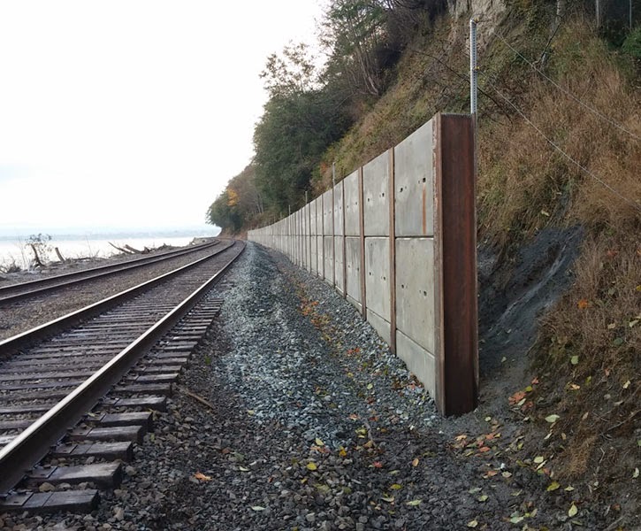 |
| Retaining walls, like this one, help catch and contain landslide debris before it can reach the tracks. |
We also, along with other work group members, held three educational open houses in communities along the north rail line to allow landowners to learn about landslide risks and prevention on their property. We met with mayors and city councils this year in Mukilteo, Edmonds and Everett about the issue. And a brochure with information and prevention tips (pdf 340 kb) was mailed to landowners along the affected rail corridor. In some cases, preventive measures are simple, such as planting native vegetation to prevent erosion and reduce the risk of landslides. New or reworked drainage systems also can help stabilize the slope and safeguard property -- as well as the rail lines. As part of this process, BNSF also agreed to waive permit fees through April 2015 for landowners who connect to the railroad’s drainage system.
- Retaining walls to catch landslide debris before it hits the tracks.
- Slide detection fences to give early warnings of active landslides.
- Improved drainage systems.
- Erosion control.
 |
| Stabilizing land and reducing the steepness of a slope, as shown here near Mukilteo, can also help prevent landslides. |
Of course, there’s never a 100 percent guarantee when you’re dealing with landslides. But by addressing landslide risks and prevention head-on, we hope to reduce at least some of Mother Nature’s impact.
During floods, better safe than sorry
Posted by Unknown in FEMA, flooding, flooding tips, floods, rain, rivers, standing water, Western Washington on Tuesday, December 9, 2014
By Barbara LaBoe

The main tip? Pay attention to weather reports and warnings and do NOT drive through standing water. According to the Federal Emergency Management Agency, that’s the cause of most flood-related deaths in Washington. It only takes six inches of water to stall a vehicle and a foot to float most vehicles, so never take the chance that you’ll be able to make it across a flooded road.
Here are some other tips from FEMA’s www.ready.gov about things you can do before and during a flood to keep you and your loved ones safe.
Before a flood:
- Create an emergency kit with medical supplies, food and water, dry clothing and important documents stored in a waterproof container.
- Get a battery-powered radio or a National Oceanic and Atmospheric Administration Weather Radio with tone alert. Stock extra batteries for both.
- Establish a family communications plan and meeting place. Know where you’ll meet if you’re separated during an evacuation. (For flooding in particular, make sure it’s on high ground). Designate a relative or friend outside the area to check in with if you’re separated and can’t reach each other. Here are some examples.
- Stash extra charging cords or portable chargers for your cellphones in your vehicles so you have them if you have to leave quickly.
 |
| If fish can swim across the highway, don’t cross. This is a photo of US 101 in 2007. |
- Remember your safety, not possessions, is your main priority. If you’re told to evacuate, do so quickly.
- Follow weather reports closely and be prepared to evacuate quickly, including having key items ready to grab as you leave.
- If there’s time before an evacuation -- and you can do it safely -- turn off utilities at the main switches or valves. Disconnect electrical appliances. Do NOT touch any electrical equipment if you are wet or are in standing water.
- Secure your home. If there’s time, move essential items to an upper floor.
- Follow WSDOT’s Facebook and Twitter pages for our flood response updates. Visit the traffic alerts page for up-to-date road closure information.
- Do not walk through moving water. Six inches of moving water can knock you down. If you have to cross water to get to safety, walk where the water is still. Use a stick to check the firmness of the ground in front of you.
- Do not drive into flooded areas. You and your vehicle can be quickly swept away. If floodwaters rise around your car unexpectedly, abandon it and move to higher ground if you can do so safely.
- Do not camp or park your vehicle along streams, rivers or creeks, even if they’re not flooding at the moment. Conditions can change quickly.
Now, just remember these tips and do your best to stay safe -- and dry -- in the days to come.
Fixing US 2 near Monroe in August so we’re ready for November
Posted by Unknown in culvert replacement, culverts, flooding, rain, US 2 on Friday, November 16, 2012
by guest blogger Bronlea Mishler
Rainy weekend forecast puts fix to the test
“When we inspected the culverts last summer, they really looked like Swiss cheese – holes everywhere,” said John Tellesbo, WSDOT’s Area 3 assistant maintenance superintendent. “We’d patched a few minor sinkholes on the shoulder, but it was just a matter of time before we got a big one that could have caused a serious problem.”
Snow. Ice. Mud. Rivers of rain. When winter weather flings its worst at the northwest, it’s not just drivers that have to bear the brunt of the unpleasantness. The roads themselves take a constant beating from the elements – and that means our maintenance crews have to be on their toes to keep the highways drivable.
Crews use the dry summer months to inspect and repair the highways – everything from filling cracks and patching potholes to replacing signs and maintaining culverts. Getting all that work done in the good weather means that the highways are prepared and ready to meet the bad weather – and that’s good news if you plan to hit the road during the winter months.
While all maintenance is important, our crews give special attention to highway drainage culverts. If you’re like most drivers, you’ve probably never noticed our culverts – that is, unless something has gone wrong. Flooding, potholes, sinkholes and big dips in the road are all highway maladies that can result from clogged or damaged culverts.
Despite our best intentions – and attention – sometimes old culverts don’t make it through a winter unscathed. There’s not much maintenance crews can do in the winter when the corroded old pipes begin to fail, except patch the resulting potholes and road divots. Until recently, the stretch of US 2 near Bickford Avenue was a particular headache for maintenance crews. Five culverts cross beneath the highway, carrying stormwater to nearby detention and treatment areas. And all five of those culverts were one storm away from falling apart.
 |
| New piping in place under US 2 |
“We’re very fortunate we fixed them when we did,” Tellesbo said. “This is one less area we have to worry about this winter – and that means our crews can be out cleaning drains and catchbasins and keeping the highways safe.”
We’re not crying wolf - some work is weather-dependent whether we like it or not
Posted by Unknown in construction, I-5, rain, weather on Wednesday, May 18, 2011
by guest blogger Lisa Copeland
A lot of behind-the-scenes planning goes into highway work zones that will have a significant impact to traffic. There are meetings, phone calls, e-mails, written drafts, corrected drafts, and eventually final drafts of news releases, all of which are sometimes pretty much washed down the drain by the whims of Mother Nature.
We can plan all we want, but in the end, a lot of the materials we use to improve our highways are weather-sensitive, which makes it difficult to pinpoint exact schedules.
A good example of this is the upcoming I-5 Clover Creek Bridge Deck Project in Pierce County.
Overlaying the bridge’s deck and replacing approach slabs requires two extended weekend closures (up to two lanes closed Friday night through Monday morning), and two weekends of Friday and Saturday night lane closures.
That’s four weekends of construction. It was scheduled to begin in April, which has five weeks, so the work could have be all done by May, right? As you saw with April's weather, it didn't match what we needed to get the work done. The work, which includes overlaying the bridge deck with a modified concrete that has rapid-cure latex in it, requires at least 45 degrees and no rain. So, as April showers continue into May, we could be in for even more delay.
But what makes some projects subject to weather while others march forward like the U.S. Postal Service through rain, sleet and snow?
If all or even a portion of a project requires dry weather, then that’s exactly what’s needed to get the job done so that the significant investment of tax dollars results in the long-term performance we expect.
It’s also why no one paints the exterior of their house in the rain. Some projects here are very similar to this – paint striping, concrete placement, asphalt paving, compacting embankments, and even putting down traffic buttons all use materials that need certain temperature and moisture conditions to ensure success. Concrete and asphalt don’t cure or compact well if temperatures are too cold and painting or putting down traffic buttons in the rain generally makes a mess, which is a waste of time and money.
Our job is to get the word out so travelers can plan ahead and defer as many trips as possible during high-impact construction projects and minimize the backups. We alert the media, post notification throughout our website, make hundreds of phone calls and send numerous e-mails asking drivers to avoid the impacted area.
We try to provide as much notice as possible and monitor weather forecasts like nervous brides planning an outdoor wedding prior to the event, but even with our best efforts, sometimes work is cancelled late in the game because of last-minute changes in the weather.
So, what can you do to help us out and still get where you need to go? Be flexible if your summer plans include travel through upcoming work zones. All of the planned highway summer construction is available at www.wsdot.wa.gov/construction/2011. A weekly look at impacts is available at www.wsdot.wa.gov/construction.
If rescheduling your trip is not an option try to find an alternate route. If travel through an impacted area is unavoidable, allow yourself plenty of extra time to reach your destination, check our website for the BEST time to travel and get the latest highway information by calling 511.
Rain causing havoc throughout state...
Posted by Unknown in flood watch, flooding, mudslide, rain, snoqualmie pass, t, wsdot on Wednesday, January 7, 2009

Summit East Slide
Originally uploaded by Washington State Dept of Transportation.
An amazing amount of rain is falling on Washington today. At one point we have counted over 60 road closures due to water over the roadway. Pictures are rolling in of the incredible damage that has been caused due to melting snow and rainfall.
This photo is of the Summit East ski area of Snoqualmie pass. Check our Flickr account throughout today and tomorrow for more pics of the terrible damage all this water is causing.
http://www.flickr.com/photos/wsdot/
|
|
|
|
|
|
|
|
|
|
|
|
|
|
|
|
|
|


